blue plaque · England

Roman Fort

Photograph at the Roman Fort blue plaque

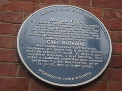
Caer Rufeinig Maw amddiffyniadau Caer Rufeinig Trefynwy, o'r ganrif 1af, o dan yr adeilad hwn, yn gyfongl i'r stryd. Yn dilyn y gaer, sefydlwyd Blestium, y dref Rufeinig. Yma hefyd y claddwyd amddiffyniadau mewnol gorllewinol y dre Normanaidd, yn yr 11 ganrif, ond yn groes-gongl.

Inscription drawn from imported open data, awaiting original TributeLegacy editorial.

Source: Open Plaques. Geographic data via OpenStreetMap.

Nearby locations in England

Browse all memorials in England

Data sources

Location records are drawn from open, licence-clean datasets, kept here with attribution and gratitude to the people who maintain them.

  • Open Plaques, dedicated to the public domain (CC0). See openplaques.org.
  • Wikidata, available under the CC0 1.0 Universal dedication.
  • © OpenStreetMap contributors, available under the Open Database Licence.
  • Historic England, National Heritage List for England, used under the Open Government Licence v3.0. War memorial records are drawn from open community datasets (OpenStreetMap, Wikidata, NHLE) — never from the Commonwealth War Graves Commission, which is excluded.

Editorial descriptions, photography and tribute links are original TributeLegacy work, layered on top of the open data.

Directions to here