
blue plaque · England

Gwesty'r Kings Head Adeiladwyd
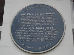
Photograph at the Gwesty'r Kings Head Adeiladwyd blue plaque

Gwesty'r Kings Head Adeiladwyd y dafarn tua chanol y 17 ganrif, a daeth yn dafarn bost wedyn. Dywedir i Siarl 1 ymweld a'r adeilad yn 1645. Gadawai'r goets fawr oddi yma i Lundain yn niwedd y 18 ganrif a dechrau'r 19 ganrif. Bu'r adeilad yn gartref i Fanc Trefynwy (1740) a'r County Club (c 1877) hefyd.

Source: Open Plaques. Geographic data via OpenStreetMap.

Nearby locations in England

Browse all memorials in England

Data sources

Location records are drawn from open, licence-clean datasets, kept here with attribution and gratitude to the people who maintain them.

  • Open Plaques, dedicated to the public domain (CC0). See openplaques.org.
  • Wikidata, available under the CC0 1.0 Universal dedication.
  • © OpenStreetMap contributors, available under the Open Database Licence.
  • Historic England, National Heritage List for England, used under the Open Government Licence v3.0. War memorial records are drawn from open community datasets (OpenStreetMap, Wikidata, NHLE) - never from the Commonwealth War Graves Commission, which is excluded.

Editorial descriptions, photography and tribute links are original TributeLegacy work, layered on top of the open data.

Directions to here