 TributeLegacy
bronze plaque · Wales
Thomas Telford
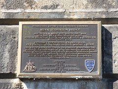
Nodwedd Peirianneg Sifil o Bwysigrwydd Hanesyddol Rhyngwladol Pont Menai Codwyd 1818-26, uchder 153TR, Hyd 1388TR. Prif rychwant 850TR. Cryfhawyd y dec 1840 & 1893. Rhoddwyd dur yn lle'r Gwaith Haearn ac Addaswyd y dec a'i ledu ar Gyfer Trafnidiaeth fodern 1939-41. Peirianwyr T. Telford 1818-34, W.A. Provis 1818-50, Syr B. Baker 1893, Syr A. Gibb & Prtn'aid 1939-41. Gwaith Carreg: J. Wilson. Dyma'r adeiladwaith pwysicaf ar y Ffordd Bwysig Sydd yn Cysylltu Llundain a Chaergybi a Thros y mor i'r iwerddon, Bryd Hynny, Hon Oedd y Bont a'r Rhychwant Hwyaf, ac yr, oedd yn Arloesol yn dechnolegol, gan ymestyn ffiniau technoleg pontydd crog ledled y Byd. Mae gan Bont Conwy (1826) a Godwyd a'r un dechnoleg arloesol, ond sydd yn llai, ei Gwaith Haern Gwreiddiol. Cyflwynwyd Gan Sefydliad Y Peirianwyr Sifil a Chymdeithas Americanaidd Y Peirianwyr Sifil 26 Mehefin 2003 International Historic Civil Engineering Landmark Menai suspension bridge. Erected 1818-26. Height 153ft. Length 1388ft. Main span 580ft. Deck strengthened 1840 & 1893. Ironwork replaced by steel-work & deck modified & widened for modern traffic 1939-41. Engineers: T. Telford 1818-34, W.A. Provis 1818-50, Sir B. Baker 1893, Sir A. Gibb & Ptnrs 1939-41. Masonry: J. Wilson. This was the major structure on the strategic road connecting London with Holyhead and by sea to Ireland. The bridge with its then world’s longest span greatly advanced suspension bridge development. The smaller Conwy suspension bridge (1826) built with identical pioneering technology still has its original ironwork. Presented by the Institution of Civil Engineers and the American Society of Civil Engineers 26 June 2003
Inscription drawn from imported open data, awaiting original TributeLegacy editorial.
Source: Open Plaques. Geographic data via OpenStreetMap.