 TributeLegacy
black plaque · Scotland
King Robert the Bruce
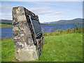
Clatteringshaws Dam. Constructed by The Galloway Water Power Company 1932-34 Clatteringshaws Dam and the loch occupy ground memorable in Scottish history; close by the dam ran the old Edinburgh road leading to Whithorn (Candida casa IV-V th century). The earliest Christian foundation in Scotland. The waters of the loch are gathered from the fastnesses of the dungeon of Buchan and from the site of that ancient forest of Buchan where Robert Bruce was hard pressed by his enemies after his return to Scotland from Rathlin in 1307. A victory gained near this place by Robert Bruce or his brother Edward is commemorated by the great boulder known as the King's or Bruce's Stone which stands near the shores of the loch 700 yards north of Clatteringshaws Farm. Mary Queen of Scots passed this way on 13th August 1563. The surrounding wilds were sought as a refuge by the covenanters during their struggles in the seventeenth century.
Inscription drawn from imported open data, awaiting original TributeLegacy editorial.
Source: Open Plaques. Geographic data via OpenStreetMap.