blue plaque · Scotland

Kilmarnock Railway Station

Photograph at the Kilmarnock Railway Station blue plaque

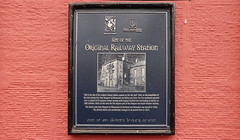
Site of the Original Railway Station This is the site of the original railway station, opened on 4th April 1843, on the completion of the first railway line from Glasgow to Kilmarnock via Paisley and Dalry. The line continued eastward over a viaduct of 23 masonry arches, curving south beyond Hurlford and terminating at Carlisle on 28th October 1850. At this time the line became part of the Glasgow and South Western Railway. The direct route from Glasgow to Kilmarnock via Barrhead and Stewarton was opened in 1873. The railway station was considerably enlarged to its present form in 1877.

Inscription drawn from imported open data, awaiting original TributeLegacy editorial.

Source: Open Plaques. Geographic data via OpenStreetMap.

Nearby locations in Scotland

Browse all memorials in Scotland

Data sources

Location records are drawn from open, licence-clean datasets, kept here with attribution and gratitude to the people who maintain them.

  • Open Plaques, dedicated to the public domain (CC0). See openplaques.org.
  • Wikidata, available under the CC0 1.0 Universal dedication.
  • © OpenStreetMap contributors, available under the Open Database Licence.
  • Historic England, National Heritage List for England, used under the Open Government Licence v3.0. War memorial records are drawn from open community datasets (OpenStreetMap, Wikidata, NHLE) — never from the Commonwealth War Graves Commission, which is excluded.

Editorial descriptions, photography and tribute links are original TributeLegacy work, layered on top of the open data.

Directions to here