Memorials and blue plaques in Ireland
Plaques, memorials and monuments across Ireland — beyond the major cities. A growing collection of the lives held in the fabric of towns and villages.
1593 locations, organised A to Z. Includes 85 war memorials.
'
"
[

[...] 1985-2005
Location details from OpenStreetMap
[...] AND HIS WIFE [...] MVRPHIE [...]
Location details from OpenStreetMap
[...] ANNO 1638 [...]
Location details from OpenStreetMap
[...] in deo A[nn]o D[omini] 1604 [...] coat armoure of th [...] niell of kilkenni warc [...] of his wife Beale Ro[the]
Location details from OpenStreetMap
[Hic] jacent Petrus Jose quondam burgensis ville d
Location details from OpenStreetMap
[Irish] James Stephens 1825-1901, Co-founder and chief of the Fenian brotherhood lived here. [Irish]
Location details from OpenStreetMap
1
1207 Callan receives charter from William Marshal 1207 Faigheann Callainn cairt ó William Marshal
Location details from OpenStreetMap
1251 St Mary's Church built 1251 Tógadh Eaglais Mhuire
Location details from OpenStreetMap
1461 Augustinian Friary founded 1461 Bunaíodh Mainistir Agaistíneach
Location details from OpenStreetMap
150th Anniversary of Railways in Cork
Location details from OpenStreetMap
15th Centenary of the birth of St-Bredan
Location details from OpenStreetMap
1604 Orate pro animabus Johannis Rothe mercatoris eius Rosae Archer [...]
Location details from OpenStreetMap
1650 - 1950 Coiste an trí-céad a cuir suas an leac seo in onoir do Aod Dubh O'Neill a cosain Cluainn Meala go calma sa mbliain 1650
Location details from OpenStreetMap
1650 Cromwell attacks Callan 1650 Deanann Cromail ionsaí ar Chaillainn
Location details from OpenStreetMap
16th Irish Division
Location details from OpenStreetMap
17 October UN International Day for the Eradication of Poverty
Location details from OpenStreetMap
1798
Location details from OpenStreetMap
1798
Location details from OpenStreetMap
1798
Location details from OpenStreetMap

1798 In memory of Anthony Perry of Perrymount, Michael Redmond of Tinnock, and the men of this district who fought so bravely for Ireland in
War Memorial
Location details from OpenStreetMap
1798 commemorative High Cross
Location details from OpenStreetMap
1798 Insurrection Memorial
Location details from OpenStreetMap
1798 Lacey Brothers Memorial
Location details from OpenStreetMap
1798 memorial
Location details from OpenStreetMap
1798 memorial
Location details from OpenStreetMap
1798 Memorial
War Memorial
Location details from OpenStreetMap
1798 Memorial
War Memorial
Location details from OpenStreetMap
1798 Memorial
War Memorial
Location details from OpenStreetMap
1798 Memorial
Location details from OpenStreetMap
1798 Memorial
Location details from OpenStreetMap
1798 Memorial
Location details from OpenStreetMap
1798 Memorial
Location details from OpenStreetMap
1798 Memorial
Location details from OpenStreetMap
1798 Memorial
Location details from OpenStreetMap
1798 Memorial
War Memorial
Location details from OpenStreetMap
1798 Memorial
Location details from OpenStreetMap
1798 Memorial
War Memorial
Location details from OpenStreetMap
1798 Memorial
War Memorial
Location details from OpenStreetMap
1798 Memorial
War Memorial
Location details from OpenStreetMap
1798 Memorial
Location details from OpenStreetMap
1798 Memorial
War Memorial
Location details from OpenStreetMap
1798 Memorial
War Memorial
Location details from OpenStreetMap
1798 Memorial
Location details from OpenStreetMap
1798 Memorial
Location details from OpenStreetMap
1798 Memorial Plaque
Location details from OpenStreetMap
1798 memorial stone
Location details from OpenStreetMap
1798 Monument
Location details from OpenStreetMap
1798 Monument
Location details from OpenStreetMap
1798 Monument
Location details from OpenStreetMap
1798 Monument
Location details from OpenStreetMap
1798 Monument
Location details from OpenStreetMap
1798 Monument
Location details from OpenStreetMap
1798 Monument
War Memorial
Location details from OpenStreetMap
1798 Rebellion
Location details from OpenStreetMap
1798 Rebellion
War Memorial
Location details from OpenStreetMap
1798 rebellion Battle of Newtownbarry (AKA Bunclody) commemorative plaque
Location details from OpenStreetMap
1798 Rebellion Memorial
Location details from OpenStreetMap
1798 Rebellion Mounment
Location details from OpenStreetMap
1841 Callan Workhouse built 1841 Togadh Teach na mBocht i gCallainn
Location details from OpenStreetMap
1866 estb., 1956 rebuilt
Location details from OpenStreetMap
1894 HRC 2019
Location details from OpenStreetMap
1902 Donovans Bridge
Location details from OpenStreetMap
1902 Droichead Doonabháin
Location details from OpenStreetMap
1910 John's Bridge rebuilt by the Corporation and County Council of Kilkenny, Ald[erman] Michael Potter, J.P., Mayor 1910
Location details from OpenStreetMap
1910 St. John's Bridge rebuilt by the County Council and Corporation of Kilkenny Joseph Walsh Esq J.P. Chairman of County Council 1902-1910
Location details from OpenStreetMap
1913 Lockout
Location details from OpenStreetMap
1914-18
d. 2014War Memorial
Location details from OpenStreetMap
1914-18
War Memorial
Location details from OpenStreetMap
1916
Location details from OpenStreetMap
1916 2016 Erected by Belgooly Tidy Villages In Commemoration Of 1916 Ar Dheis De go raibh a Anam Dius
Location details from OpenStreetMap
1916 Bench
Location details from OpenStreetMap
1916 Centenery Commemoration
Location details from OpenStreetMap
1916 Easter Rising
Location details from OpenStreetMap
1916 Memorial
War Memorial
Location details from OpenStreetMap
1916 Memorial
War Memorial
Location details from OpenStreetMap
1916 Memorial Garden
Location details from OpenStreetMap
1916 Monument
Location details from OpenStreetMap
1916 Rising
Location details from OpenStreetMap
1916 Rising
Location details from OpenStreetMap
1916 volunteers meeting point
Location details from OpenStreetMap
1916-1991 Planted by O.N.E. to commemorate 75th anniversary of Easter Rising
Location details from OpenStreetMap
1916-2016
Location details from OpenStreetMap
1916-2016 To the men and women who fought and died in the 1916 Rising
Location details from OpenStreetMap
1926-2009. George Thomas. A man of the land, a true gentleman, a historian and a generous benefactor.
Location details from OpenStreetMap
1940 Plough
Location details from OpenStreetMap
1974 Dublin and Monaghan Bombings Memorial
Location details from OpenStreetMap
1974 Dublin Bombing
Location details from OpenStreetMap
1981 Hunger Strikers
Location details from OpenStreetMap
1987
Location details from OpenStreetMap
1988 in this house Kader Asmal and Albie Sachs drafted the South African Bill of Rights which would later be incorporated in the constitutio
Location details from OpenStreetMap
1992 McGuinness House in recognition of a lifetime of service to Kilkenny by Councillor M. J. McGuinness, Mayor of Kilkenny 1957, 58, 65, 66
Location details from OpenStreetMap
1999 Helicopter Crash
The Promenade, Tramore
2
4
9
A
A Gift from the United Mexican States to Ireland
Location details from OpenStreetMap
A weaver from Courtclogh named Quinsey
Location details from OpenStreetMap
A.W.B. (Billy) Vincent Memorial
Location details from OpenStreetMap
Abbey Quarter
Location details from OpenStreetMap
Abbey Quarter
Location details from OpenStreetMap
Abbey Street Improvements undertaken during the Mayorality of Councillor Betty Manning 2002-2003
Location details from OpenStreetMap
Aby Mills Built by Patrick O Connell in the year 1791.
Location details from OpenStreetMap
AD 1782
Location details from OpenStreetMap
AD 88
Location details from OpenStreetMap
AD MDCCCV
Location details from OpenStreetMap
Admiral William Brown
Location details from OpenStreetMap
Admiral William Brown
Location details from OpenStreetMap
Africa is represented by a stone from the grounds of the Groote Schuur hospital in Cape Town where Dr. Christiaan Barnard preformed the firs
Location details from OpenStreetMap
Aghacarrible Rock Art
Location details from OpenStreetMap
Air India Flight 182 Crash Memorial
Location details from OpenStreetMap
Aircraft Memorial 1976
Location details from OpenStreetMap
Aisling Murphy Memorial
Location details from OpenStreetMap
Alcock and Brown Atlantic Crossing
Location details from OpenStreetMap
Alcock and Brown Crash Site
Location details from OpenStreetMap
Alexander Nimmo
Location details from OpenStreetMap
Alice and Gwendoline Cave
Location details from OpenStreetMap
Alice Taylor Monument
Location details from OpenStreetMap
Allen family memorial headstone
Location details from OpenStreetMap
Ambrose Power Memorial
Location details from OpenStreetMap
Ambrosio and Bernado O'Higgins
Location details from OpenStreetMap
Amicus Americanis
Location details from OpenStreetMap
An Canónach Liam Ó Carragáin P.P. M.R.I.A. Staraí Osraí Chónaigh sa teach seo,1909-1924. Sagart léanta, fial, dúthrachtach. "Glór na nGael"
Location details from OpenStreetMap
An Fearban
Location details from OpenStreetMap
An Torpedo
Location details from OpenStreetMap
An Trá bPáistí, Cumdaithe, I mbaclainn Muire, go luid a Thiarna, Ar naíonáin gan ainm, Is ár ngaolta caoine, A sciobadh uainn, le linn an Go
Location details from OpenStreetMap
Anchor
Location details from OpenStreetMap
Anchor
Location details from OpenStreetMap
Anchor of the 'Varity' (stranded 1890)
Location details from OpenStreetMap
Anchor The Saga
Location details from OpenStreetMap
Ancient Order of Hibernians Memorial
Location details from OpenStreetMap
And I shall have some peace there.
Location details from OpenStreetMap
Andrew Fay
Location details from OpenStreetMap
Angela Davidson Nee Meighan 1965 - 2005
Location details from OpenStreetMap
Angela Delaney
Location details from OpenStreetMap
Anglo American Cable House, Telegraph Field
Location details from OpenStreetMap
Anna Parnell
Location details from OpenStreetMap
Annestown monument
Location details from OpenStreetMap
Annie Moore
Location details from OpenStreetMap
Another Season
Location details from OpenStreetMap
Anthony Foley Memorial
Location details from OpenStreetMap
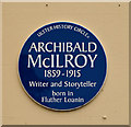
Archibald McIlroy
Ballyclare
Ardagh Clock Tower
Location details from OpenStreetMap
Arkle
Location details from OpenStreetMap
Arklow
Location details from OpenStreetMap
Art Ó Gríobhtha
Location details from OpenStreetMap
Art O'Neill Cross
Location details from OpenStreetMap
Art O'Neill Plaque
Location details from OpenStreetMap
Arthur Charles Smith Memorial
Location details from OpenStreetMap
Arthur Guiness
Location details from OpenStreetMap
Arthur Guinness Grave
Location details from OpenStreetMap
Arthur Guinness the Second
Location details from OpenStreetMap
Arthur McMahon Mayor 1877
Location details from OpenStreetMap
Artillery Memorial
Location details from OpenStreetMap
Ascaill Mac Shinesin Jink's Avenue In honour of Mr. John Jink's Mayor of Sligo 1914 - 17 & 1921
Location details from OpenStreetMap
Ashbourne
Location details from OpenStreetMap
Ashbury Sign
Location details from OpenStreetMap
Assassination of Thomas Mac Curtain
Location details from OpenStreetMap
Assembly Rooms
Location details from OpenStreetMap
Atha Tomais
Location details from OpenStreetMap

Athy War Memorial
d. 2015War Memorial
Location details from OpenStreetMap
Athy War Memorial
War Memorial
Location details from OpenStreetMap
Augustinian Monks Memorial Statue
Location details from OpenStreetMap
Austin Clarke Bridge
Location details from OpenStreetMap
Á
B
B2JL
Location details from OpenStreetMap
Balisland
Location details from OpenStreetMap
Ballast Quay
Location details from OpenStreetMap
Ballinlass Eviction Memorial
Location details from OpenStreetMap
Ballinskelligs Bay memorial
Location details from OpenStreetMap
Ballybough Burial Plot
Location details from OpenStreetMap
Ballyboughal
Location details from OpenStreetMap
BallyCannon Boys Memorial
Location details from OpenStreetMap
Ballyellis
Location details from OpenStreetMap
Ballygullen
Location details from OpenStreetMap
Ballyhooriksy Monument
Location details from OpenStreetMap
Ballyhourigan Mass Rock
Location details from OpenStreetMap
Bandon IRA Memorial
Location details from OpenStreetMap
Bandon War Memorial
War Memorial
Location details from OpenStreetMap
Bardás Chorcaí Bealach Lasnairde Thobhar An Airgid A osclaíodh ar an 2ú Lá de Meitheamh 1988 ag An Ardmhéra Tomás Ó Brosnacháin I Láthair An
Location details from OpenStreetMap
Barley Hill
Location details from OpenStreetMap
Barnageeragh Cove Skerries
Location details from OpenStreetMap
Barraduff
Location details from OpenStreetMap
Barrowhouse Ambush
Location details from OpenStreetMap
Bartholomew Mosse
Location details from OpenStreetMap
Battle of Castlehaven
Location details from OpenStreetMap
Battle of the Big Cross (1798) Memorial Monument
Location details from OpenStreetMap
Battle Of The Three Rocks
Location details from OpenStreetMap
Battle of Vinegar Hill, 1798
Location details from OpenStreetMap
Bayard Warren Plaque
Location details from OpenStreetMap
Beacon Hill
Location details from OpenStreetMap
Beech Hill Office Campus
Location details from OpenStreetMap
Belgard Road
Location details from OpenStreetMap
Belgooly National School 1870
Location details from OpenStreetMap
Bell
Location details from OpenStreetMap

Berehaven Battalion Memorial
War Memorial
Location details from OpenStreetMap
Berehaven Battalion Memorial
War Memorial
Location details from OpenStreetMap
Bernard Dunne Memorial Bench
Location details from OpenStreetMap
Bernardo O'Higgins
Location details from OpenStreetMap
Bi-Centenary of 1798
Location details from OpenStreetMap
Bianconi Archway
Location details from OpenStreetMap
Big Tom Memorial Statue
Location details from OpenStreetMap
Bingo / Colour Sergeant Dermot Butler / 1955-2002 / Rest in Peace / Died 8th Nov 2002 due to an accident at this spot on 25th Oct 2002 while
Location details from OpenStreetMap
Birr Little Theatre
Location details from OpenStreetMap
Birthplace of General Philip Sheridan
Location details from OpenStreetMap
Birthplace of James Joyce
Brighton Square, Dublin
Bishop Mahony
Location details from OpenStreetMap
Bithia Mary Croker
Location details from OpenStreetMap
Black Abbey Carpark
Location details from OpenStreetMap
Black Friars Gate
Location details from OpenStreetMap
Blake's Castle
Location details from OpenStreetMap
Blue School
Location details from OpenStreetMap
Bob Adams
Location details from OpenStreetMap
Bobbyjo
Location details from OpenStreetMap
Boer War Memorial
d. 1904War Memorial
Location details from OpenStreetMap
Boer War Memorial
War Memorial
Location details from OpenStreetMap
Bog Oak
Location details from OpenStreetMap
Bogland
Location details from OpenStreetMap
Bomb Victims Memorial
Location details from OpenStreetMap
Bombing 1975
Location details from OpenStreetMap
Bombing 1975
Location details from OpenStreetMap
Bombing of the North Strand
Location details from OpenStreetMap
BORANARALTRY BRIDGE REBUILT DECEMBER 1905
Location details from OpenStreetMap
Borough Boundary 1895. Edward Cantwell, Alderman J. R., Mayor, John F. O'Brien, Town Clerk
Location details from OpenStreetMap
Borough boundary Edm Smithwick Mayor 1844
Location details from OpenStreetMap
Borough boundary Edm Smithwick Mayor 1844
Location details from OpenStreetMap
Borough boundary Edm Smithwick Mayor 1844
Location details from OpenStreetMap
Borough boundary Edmd Smithwick 1844 Mayor
Location details from OpenStreetMap
Borough boundary Edmd Smithwick 1844 Mayor
Location details from OpenStreetMap
Borough boundary Edmd Smithwick Mayor 1844
Location details from OpenStreetMap
Borough boundary Edmd Smithwick Mayor 1844
Location details from OpenStreetMap
Borough boundary Edmd Smithwick Mayor 1844
Location details from OpenStreetMap
Borough boundary Edmd Smithwick Mayor 1844
Location details from OpenStreetMap
Borough boundary Edmd Smithwick Mayor 1844
Location details from OpenStreetMap
Borough boundary. 1895. Edward Cantwell Alderman, J.P. Mayor, John F. O'Brien, Town Clerk
Location details from OpenStreetMap
Boucher's Obelisk
Location details from OpenStreetMap
Bray Cross
Location details from OpenStreetMap
Bricolie's Bed
Location details from OpenStreetMap
Bridge Memorial (Kenna)
Location details from OpenStreetMap
Broadford Mass Rock
Location details from OpenStreetMap
Brother Walfrid
Location details from OpenStreetMap
Brothers Sculpture
Location details from OpenStreetMap
Bruse Hill Trail
Location details from OpenStreetMap
Bryan MacMahon
Location details from OpenStreetMap
Built by the Corporation Alderman Rowan Mayor 1892.
Location details from OpenStreetMap
Built under the patronage of Robert Lord Bishop of Ossory [...] 1820
Location details from OpenStreetMap
Bun Clóidí
Location details from OpenStreetMap
Bun-na-Cnoic
Location details from OpenStreetMap
Bunchloch (Foundation Stone)
Location details from OpenStreetMap
Bunclody 1798 Bicentenary Memorial
Location details from OpenStreetMap
Burial Ridge of Maryborough
Location details from OpenStreetMap
Butler Memorial
Location details from OpenStreetMap
Buttevant Rail Disaster
Location details from OpenStreetMap
By Hook or By Crook
Location details from OpenStreetMap
C
c.1200 Motte and bailey built c.1200 Tógadh móta agus bábhún
Location details from OpenStreetMap
c1339 Callan town walls built c1339 Críochnaíodh tógáil bhallaí bhaile Challainne
Location details from OpenStreetMap
Cairn of Peace
Location details from OpenStreetMap
Caldbeck Memorial Fountain
Location details from OpenStreetMap
Callan 800 In 1207 this lane led to the Norman settlement around the motte of Callan. In 2007 Minister Dick Roche inaugurated this voluntary
Location details from OpenStreetMap
Callan Co-operative Agricultural & Dairy Society Ltd.
Location details from OpenStreetMap
Callan Great War Memorial
War Memorial
Location details from OpenStreetMap
Callan Macra na Feirme 1946-1996
Location details from OpenStreetMap
Calvary
Location details from OpenStreetMap
Campile WWII Bombing Memorial
War Memorial
Location details from OpenStreetMap
Cannon
Location details from OpenStreetMap
Captain Séan Connolly
Sean MacDermott Street Lower, Dublin
Captain Thomas Sheridan IRA
Location details from OpenStreetMap
Carey's Forge Grinding wheel and cooling trough
Location details from OpenStreetMap
Carlanstown Group Water Scheme
Location details from OpenStreetMap
Carlingford Ogham Stone
Location details from OpenStreetMap
Carmen Stegarescu 1963 - 2011
Location details from OpenStreetMap
Carney's Cottage 1863
Location details from OpenStreetMap
Carraig an Aifrinn 1798-1974
Location details from OpenStreetMap
Carrickshock Memorial
Location details from OpenStreetMap
Carrig House
Location details from OpenStreetMap
Castlecomer
Location details from OpenStreetMap
Castletown Trail
Location details from OpenStreetMap
Cathair Chill Chainnigh. Buaiteoir Shraithchomórtas frithbhruscair 2012 IBAL. An Méara, an Comh. Seán Ó hArgáin
Location details from OpenStreetMap
Cathal Hurley Memorial
Location details from OpenStreetMap
Catherine McAuley
Location details from OpenStreetMap
Cé Lavitt
Location details from OpenStreetMap
Cecil Day Lewis
Location details from OpenStreetMap
Celebrating 125 Years
Location details from OpenStreetMap
Celebrating Community
Location details from OpenStreetMap
Celtic Cross Monument to De Vere Family
Location details from OpenStreetMap
Celtic Cross Monument to Robert Stephen De Vere
Location details from OpenStreetMap
Cenotaph
Location details from OpenStreetMap
Centre Ward No. 5
Location details from OpenStreetMap
Cerberus, from Thomastown House
Location details from OpenStreetMap
Chapel Farm
Location details from OpenStreetMap
Chapel Farm
Location details from OpenStreetMap
Chapelizod Bypass
Location details from OpenStreetMap
Charles Bianconi
Location details from OpenStreetMap
Charles Bianconi
Location details from OpenStreetMap
Charles Bunworth
Location details from OpenStreetMap
Charles Haughey
Location details from OpenStreetMap
Charles Kerins Monument
Location details from OpenStreetMap
Charles Stewart Parnell
Location details from OpenStreetMap
Charles Stewart Parnell Monument
Location details from OpenStreetMap
Charlie Hurley Memorial
Location details from OpenStreetMap
Christ the King
Location details from OpenStreetMap
Christ the King
Location details from OpenStreetMap
Christian Brothers
Location details from OpenStreetMap
Christian Brothers Schools Established 1868. This is the original school sign from the first Christian Brothers' School built on this site i
Location details from OpenStreetMap
Christopher Columbus Monument
Location details from OpenStreetMap
Christopher McClynn
Location details from OpenStreetMap
Christopher Thompson
Location details from OpenStreetMap
Chrysler
Location details from OpenStreetMap
Church of Ireland
Location details from OpenStreetMap
Churchtown Horse Racing Heritage
Location details from OpenStreetMap
Cillín Hill. Kilkenny Co-operative Livestock Market Ltd. Established 1956. Cillín Hill Centre officially opened by Mary Coughlan, TD. Minist
Location details from OpenStreetMap
Cillín Memorial
Location details from OpenStreetMap
City Wall c.1275
Location details from OpenStreetMap
City Wall c.1275
Location details from OpenStreetMap
City Wall c.1275
Location details from OpenStreetMap
City Walls
Location details from OpenStreetMap
City Walls
Location details from OpenStreetMap
City Walls c.1275
Location details from OpenStreetMap
Civic award 1985 Kilkenny Corporation
Location details from OpenStreetMap
Civil War Memorial
War Memorial
Location details from OpenStreetMap
Cleggan fishing disaster 28th October 1927
Location details from OpenStreetMap
Cloch na gCoillte
Location details from OpenStreetMap
Cloghanearone Cillín
Location details from OpenStreetMap
Clonard
Location details from OpenStreetMap
Clonfin Ambush Memorial
War Memorial
Location details from OpenStreetMap
Clonmel Corporation Working class dwellings erected 1900. Thomas Condon Ald. Mayor, M.P. East Tipperary
Location details from OpenStreetMap
Clontarf War Memorial
War Memorial
Location details from OpenStreetMap
Clover's Lane
Location details from OpenStreetMap
Clyde Shipping Company
Location details from OpenStreetMap
Cnoc Seanratha
Location details from OpenStreetMap
Cnoc Tiarnach
Location details from OpenStreetMap
Coiseanna Hill 1798
Location details from OpenStreetMap
Col. James Fitzmaurice
Location details from OpenStreetMap
College Green St. Patrick's Community Homes Rev. J. Robinson C.C. President October 30th 1980, built by the workers of the parish.
Location details from OpenStreetMap
College Street
Location details from OpenStreetMap
Colonel James Fitzmaurice
Location details from OpenStreetMap
Come and Go 1966
Location details from OpenStreetMap
Comhlucht na hÉireann um Árachas cpt
Location details from OpenStreetMap
Commemorative Tower to the Hobblers
Location details from OpenStreetMap
Commodore John Barry Memorial
Location details from OpenStreetMap
Comóradh 1798
Location details from OpenStreetMap
Confederate Hall
Location details from OpenStreetMap
Conor Hickey - 3 December 2011
Location details from OpenStreetMap
Conor Lucey
Location details from OpenStreetMap
CONVENT OF MERCY 1908-2000. Site of the school established by the Sisters of Mercy, an Irish congregation dedicated to the education and car
Location details from OpenStreetMap
Coolaghmore National School
Location details from OpenStreetMap
Cooley Cross
Location details from OpenStreetMap
Cork 800 Memorial
Location details from OpenStreetMap
Cork Corporation Leitrim Street Road Improvement and Kiln River Drainage Scheme This scheme was commissioned on 10th July 1992 by The Right
Location details from OpenStreetMap
Cork Corporation Silversprings Overpass Opened 2nd June 1988 by The Right Honourable The Lord Mayor Councillor Tom Brosnan in the Presence o
Location details from OpenStreetMap
Cork Harbour Commissioners
Location details from OpenStreetMap
Cork Harbour Tragedy
Location details from OpenStreetMap
Cork Simon Community
Location details from OpenStreetMap
Cork War Memorial
War Memorial
Location details from OpenStreetMap
Corkagh Demesne
Location details from OpenStreetMap
Cornafean GFC
Location details from OpenStreetMap
Coronation Plantation Monument
Location details from OpenStreetMap
Corporation of Cork Labours Dwellings. This stone was laid by the Right Honourable Ald. Sir Daniel Hegarty J.P. (first) Lord Mayor of Cork N
Location details from OpenStreetMap
Corrigans Corner
Location details from OpenStreetMap
Corrin Cross
Location details from OpenStreetMap
Councillor Jim Miley
Location details from OpenStreetMap
Count John McCormack
Location details from OpenStreetMap
Creamery House
Location details from OpenStreetMap
Crimea Cannon and War Memorial
War Memorial
Location details from OpenStreetMap
Crimean War cannon
Location details from OpenStreetMap
Crois Na Leanbh Memorial
Location details from OpenStreetMap
Cromwell's Bridge
Location details from OpenStreetMap
Croppies Acre Memorial
Location details from OpenStreetMap

Croppies' Grave
War Memorial
Location details from OpenStreetMap
Cross
Lehaunstown
Cross
Location details from OpenStreetMap
Cross
Location details from OpenStreetMap
Cross
Location details from OpenStreetMap
Cross commemorating Holy Day.
Location details from OpenStreetMap
Crowley
Location details from OpenStreetMap
Crutched Friars
Location details from OpenStreetMap
Cúchulainn
Location details from OpenStreetMap
Cumann Lúcthleas Gael An Chabáin 1887
Location details from OpenStreetMap
Cumann Lúthchleas Gael
Location details from OpenStreetMap
Cumann Uinsinn Naofa
Location details from OpenStreetMap
Cunard Líne Offices
Location details from OpenStreetMap
D
D.O.M. Primarium hunc lapidem posuit revmus et exmus Patricius Collier D.D. Die X Junii MCMLVI 1956 pro papa XII feliciter regnante deo adju
Location details from OpenStreetMap
Dad
Location details from OpenStreetMap
Dame Ninette de Valois
Location details from OpenStreetMap
Dan[ie]l Cullen Mayor 1852
Location details from OpenStreetMap
Dandelion Statue
Location details from OpenStreetMap
Danesfort Cross
Location details from OpenStreetMap
Daniel Crowley
Location details from OpenStreetMap
Daniel Florence O'Leary Birthplace
Location details from OpenStreetMap
Daniel Murphy
Location details from OpenStreetMap
Daniel O'Connell
Location details from OpenStreetMap
Daniel O'Connell, 1775-1847 "The Liberator" architect of Catholic Emancipation defended a decisive political action in this courthouse, 1822
Location details from OpenStreetMap
Danno O’Mahony statue
Location details from OpenStreetMap
Danny Dúis McCarthy
Location details from OpenStreetMap
Daubney Fountain
Location details from OpenStreetMap
David Hurley
Location details from OpenStreetMap
David Luke 1993
Location details from OpenStreetMap
Dawson Monument
Location details from OpenStreetMap
Dawson Monument
Location details from OpenStreetMap
De Gaulle Memorial
Location details from OpenStreetMap
Deaf Hugh's Well
Location details from OpenStreetMap
Deasys Old Brewery
Location details from OpenStreetMap
Declaration of Independence
Location details from OpenStreetMap
Dedicated to the Memory of the Men and Women who courageously sustained the noble cause of Irish freedom 1916 - 1921 We remember all those
War Memorial
Location details from OpenStreetMap
Dedicated to the people who were laid to rest in this area. R.I.P. erected by Blackmill St. residents 1998.
Location details from OpenStreetMap
Deerpark
Location details from OpenStreetMap
Delaney
Location details from OpenStreetMap
Delaney Brothers Monument
Location details from OpenStreetMap
Dempsey
Location details from OpenStreetMap
Denny Lane
Location details from OpenStreetMap
dermot and grainnes bed
Location details from OpenStreetMap
Des (H) Hayward 1964-2007 Gone with Nash to rest "on the dark side of the moon"
Location details from OpenStreetMap
Dick Joynt Memorial
Location details from OpenStreetMap
Dinny Barry Memorial
Location details from OpenStreetMap
DM Pender
Location details from OpenStreetMap
Docker's Monument
Location details from OpenStreetMap
Don Allum
Location details from OpenStreetMap
Donabate Distributor Road
Location details from OpenStreetMap
Donnchadh Mac Niallghuis
Location details from OpenStreetMap
Donnelly's Hollow
Location details from OpenStreetMap
Donnybrook Cemetery
Location details from OpenStreetMap
Donovan
Location details from OpenStreetMap
Doo Lough Valley and Famine Memorial
Location details from OpenStreetMap
Doolough Tragedy 1849 Memorial
Location details from OpenStreetMap
Dr George Sigerson
Location details from OpenStreetMap
Dr. Isaac Usher
Location details from OpenStreetMap
Drinking Well
Location details from OpenStreetMap
Droichead Naomh Pádraig Saint Patrick's Bridge Unveiled 16th of March 2019 By the Lord Mayor of Cork, Cllr. Mick Finn
Location details from OpenStreetMap
Droichead Uí Ghríofa
Location details from OpenStreetMap
Drowning in Dunmanus Bay
Location details from OpenStreetMap
Dublin and Monaghan Bombings
Location details from OpenStreetMap
Dublin and Monaghan Bombings Memorial
Location details from OpenStreetMap
Dublin Gaslight Company 1825
Location details from OpenStreetMap
Dublin Millennium
Location details from OpenStreetMap
Dublin Tourism Artist Patrick Swift 1927-1983 Lived and painted here in the 1950s
Location details from OpenStreetMap
Duffry Gate
Location details from OpenStreetMap
Duke of Downshire Monument
Location details from OpenStreetMap
Dun Laoghaire Golf Club. Founded 1910
Location details from OpenStreetMap
Dungarvan World War I Memorial
War Memorial
Location details from OpenStreetMap
Dunlop Tyre Factory
Location details from OpenStreetMap
E
Eagle Obelisk
Location details from OpenStreetMap
Earl of Desart Mayor 1810
Location details from OpenStreetMap
East Gate
Location details from OpenStreetMap
East Mayo Brigade Monument
d. 1972War Memorial
Location details from OpenStreetMap
East Point
Location details from OpenStreetMap

Easter 1916 Memorial
War Memorial
Location details from OpenStreetMap
Easter 1916 Memorial
War Memorial
Location details from OpenStreetMap
Easter Rising
Location details from OpenStreetMap
Eddie (Ned) Slane
Location details from OpenStreetMap
Eddie Power
Location details from OpenStreetMap
Edgeworthstown Bypass
Location details from OpenStreetMap
Edmund Ignatius Rice born here in Westcourt 1st June 1762 died at Mount Sion Waterford 29 august 1844. Providence is our inheritance.
Location details from OpenStreetMap
Edmund Rice Memorial
Location details from OpenStreetMap
EDWARD [...] GRA REX ANGLIE FRANCIE ET HIBERNIE [...] VI
Location details from OpenStreetMap
Edward Bransfield
Location details from OpenStreetMap
Edward Burke
Location details from OpenStreetMap
Elias Shee coat-of-arms
Location details from OpenStreetMap
Elizabeth Drummond Gate
Location details from OpenStreetMap
Elizabeth O'Farrell Park
Location details from OpenStreetMap
Ella the Buttermaker
Location details from OpenStreetMap
Emigration Memorial
Location details from OpenStreetMap
Emma Jane Browne-Clayton
Location details from OpenStreetMap
Emmet Place
Location details from OpenStreetMap
Enclosure / or ringort
Location details from OpenStreetMap
End / Start of Wicklow Way
Location details from OpenStreetMap
Enda Colleran Memorial
Location details from OpenStreetMap
Endurance Monument
Location details from OpenStreetMap
Enniscorthy
Location details from OpenStreetMap
Entrance to former Parish Church of Our Lady 1770-1833.
Location details from OpenStreetMap
Eoin MacNeill
Location details from OpenStreetMap
Ephraim Saks
Location details from OpenStreetMap
Erected at the expense of the Co. Kilkenny August 1818. During the Sovereignty HUMPHREY HARTLEY Esq. JP. Middle arch destroyed 1922, restore
Location details from OpenStreetMap
Erected by Clonmel Bianconi Twinning Committee to commemorate the 200th anniversary of the first Bianconi coach leaving Hearns Hotel for Ca
Location details from OpenStreetMap
Erected by the Muinebheag Town Commission To the Memory Of The Six Men Executed in Market Square In 1798. I bhflaitheas Dé go raibh siad uil
Location details from OpenStreetMap
Erected in 2005 To commemorate the centenary of the publication of The History and Antiquities of the Diocese of Ossory by William Canon Car
Location details from OpenStreetMap
Erected in memory of Terry Brett who died tragically at this spot on 2nd December 1978 aged 18 years. Always remembered by his loving family
Location details from OpenStreetMap
Erected in the memory of all the people of Athenry and surrounding areas who fought and those who died in WW1
Location details from OpenStreetMap
Erected Jan. 1893 by public subscription to commemorate the memory of Dr. Wm. Ashford for the valuable services he rendered for a period of
Location details from OpenStreetMap
ERECTED TO THE MEMORY OF THE HON. A.M. KAVANAGH AS A TOKEN OF THE ADMIRATION AND RESPECT WITH WHICH HE WAS REGARDED BY MANY FRIENDS
Location details from OpenStreetMap
Erected under corporation building scheme John Magennis P.L.C. Mayor of Kilkenny 1914-1915 and 1916
Location details from OpenStreetMap
Erected under corporation building scheme John Magennis P.L.G. Mayor of Kilkenny 1914-15 and 1916.
Location details from OpenStreetMap
Erected under corporation building scheme. John Magennis P.L.C. Mayor of Kilkenny 1914-15-16.
Location details from OpenStreetMap
Erected under corporation building scheme. John Magennis PLC Mayor of Kilkenny 1914-15 and 1916.
Location details from OpenStreetMap
Erin's Hope 1867
Location details from OpenStreetMap
Ernest Shackleton
Location details from OpenStreetMap
Ernest Shackleton
Location details from OpenStreetMap
Estate Yard
Location details from OpenStreetMap
Ettie Gluck born Steinberg
Location details from OpenStreetMap
European Competition for towns and villages in Bloom 2017 Silver Award
Location details from OpenStreetMap
Executions of the leaders of the 1916 rising
Location details from OpenStreetMap
É
F
Fair of Muff
Location details from OpenStreetMap
Fairy's House
Location details from OpenStreetMap
Falla Seilscear
Location details from OpenStreetMap
Fallen Jockey Monument
Location details from OpenStreetMap
Famine
Location details from OpenStreetMap
Famine Memorial
Lower Quay Street, Sligo
Famine Memorial
Location details from OpenStreetMap
Famine Memorial
Location details from OpenStreetMap
Famine Memorial
Location details from OpenStreetMap
Famine Memorial Garden
Castlecomer Road, Kilkenny
Famine Pot
Location details from OpenStreetMap
Famine Ship Memorial
Location details from OpenStreetMap
Famine stone
Location details from OpenStreetMap
Famous Horses of Kells
Location details from OpenStreetMap
Fastnet Lighthouse Centenary Stone-Course
Location details from OpenStreetMap
Father Burbage
Location details from OpenStreetMap
Father John Murphy Memorial
Location details from OpenStreetMap
Father Mathew
Location details from OpenStreetMap
Father Matthew
Saint Patrick Street, Cork
Father Moore's Well
Location details from OpenStreetMap
Father Theobald Mathew O.F.M. CAP. Apostle of Temperance died in this house December 8th 1856.
Location details from OpenStreetMap
Faugh a Ballagh 1914-1918
Location details from OpenStreetMap
Ferrari Horse Statue
Location details from OpenStreetMap
Ferrycarrig Ambush
Location details from OpenStreetMap
Fiddown Bridge
Location details from OpenStreetMap
Fighting 69th Monument
Location details from OpenStreetMap
File mór na nDéise Tadhg Gaelach Ó Súilleabháin 1715-1795 a d'éag san ardeaglais
Location details from OpenStreetMap
Film cell plaque № 40737
Hall Street

Fire hose monument
War Memorial
Location details from OpenStreetMap
Fire hose monument
War Memorial
Location details from OpenStreetMap
Fireman John Kite
Location details from OpenStreetMap
Fireman Richard Beecher, died 12 Feb 1975
Location details from OpenStreetMap
First All Ireland Football Final
Location details from OpenStreetMap
First World War Memorial
War Memorial
Location details from OpenStreetMap
Fisher's Cross
Location details from OpenStreetMap
Fitzmaurice Place
Location details from OpenStreetMap
Flower Bed
Location details from OpenStreetMap
Footballers Statue
Location details from OpenStreetMap
Former Customs House and Mercantile Marine Office
Location details from OpenStreetMap
Former US Lines Office
Location details from OpenStreetMap
Fort of Maryborough
Location details from OpenStreetMap
Fort Protector
Location details from OpenStreetMap
Fortgranite House
Location details from OpenStreetMap
Foulksmills
Location details from OpenStreetMap
Foundation Stone Blessed by Pope John Paul II 1979
Location details from OpenStreetMap
Foundation stone for new government offices phase II Kilkenny. Laid by Mr. Hugh Coveney T.D., Minister of State at the Department of Finance
Location details from OpenStreetMap
Founded 1888 by the corporation P. M. Egan Mayor 1887-1888
Location details from OpenStreetMap
Founded 1888 by the corporation P. M. Egan Mayor 1887-1888
Location details from OpenStreetMap
Founded 1888 by the corporation P. M. Egan Mayor 1887-1888
Location details from OpenStreetMap
Founded 1888 by the corporation P. M. Egan Mayor 1887-1888
Location details from OpenStreetMap
Founded by the corporation Alderman David Fenton Mayor 1890
Location details from OpenStreetMap
Founded by the corporation Michael Kennedy Esq. Mayor 1891
Location details from OpenStreetMap
Four Masters Bridge
Location details from OpenStreetMap
Four Masters Memorial
Location details from OpenStreetMap
Fourth Battalion Dublin Brigade
War Memorial
Location details from OpenStreetMap
Fr Burke Statue
Location details from OpenStreetMap
Fr Tommy Maher Field Officially unveiled by Mícheál Ó Muircheartaigh 1st July 2017
Location details from OpenStreetMap
Fr. Vincent Daly Park Altar
Location details from OpenStreetMap
Francis Hopkins
Location details from OpenStreetMap
Francis McManus Square, officially opened by Ald. Joe Cody Mayor Kilkenny Borough Council June 2002
Location details from OpenStreetMap
Francis O'Neill Plaque
Location details from OpenStreetMap
Francis turbine
Location details from OpenStreetMap
Frank Duff
Location details from OpenStreetMap
Frank Kellett
Location details from OpenStreetMap
Frank Meehan 1926-2012. O Solitude where are the charms.
Location details from OpenStreetMap
Frank Patterson
Location details from OpenStreetMap
Frederick Douglass
Location details from OpenStreetMap
Frederick Douglass
Location details from OpenStreetMap

French Hill Monument
War Memorial
Location details from OpenStreetMap
French Hill Monument
War Memorial
Location details from OpenStreetMap
French Landing 1798
Location details from OpenStreetMap
Freshford Female National School founded by Thomas Eyre Esq Uppercourt May 10th 1876
Location details from OpenStreetMap
Full text of the Proclamation of the Irish Republic
Location details from OpenStreetMap
G
G.A.A. Commemorative Stone
Location details from OpenStreetMap
Gaelic Athletic Association 100th Anniversary
Location details from OpenStreetMap
Gairdín Cuimhneacháin an Gharda Síochána
Location details from OpenStreetMap
Gairdín Gharraí na Leadhb
Location details from OpenStreetMap
Gairdín Súgartha i gCuimhne ar na Páistí a Cailleadh in 1916
Location details from OpenStreetMap
Galway Gaol
Location details from OpenStreetMap
Gaol Cross
Location details from OpenStreetMap
Garden of Remembrance
War Memorial
Location details from OpenStreetMap
Garden of Remembrance
Location details from OpenStreetMap
Gary Miller Memorial
Location details from OpenStreetMap
Geevagh Prisoners 1908 Memorial
Location details from OpenStreetMap
General George O'Malley
Location details from OpenStreetMap
General Michael Collins Commander-in-chief of the National Army, visited this hotel on 22 August 1922. Shortly after his departure, his co
Location details from OpenStreetMap
General Thomas Cloney
Location details from OpenStreetMap
Geoffrey of Waterford c1266 Dominican Scholar of Arabic Greek & Latin lived here
Location details from OpenStreetMap
George Boole
Location details from OpenStreetMap
George Boole
Location details from OpenStreetMap
George IV's footsteps
Location details from OpenStreetMap
George Russell (AE)
Location details from OpenStreetMap
Glanmire Heritage Society
Location details from OpenStreetMap
Gleeson Memorial
Location details from OpenStreetMap
Glenour Monument
War Memorial
Location details from OpenStreetMap
Glenour Monument
War Memorial
Location details from OpenStreetMap
Gone Fishing
Location details from OpenStreetMap
Goold Monument
Location details from OpenStreetMap
Gorden Bennet Race memorial
Location details from OpenStreetMap
Gorey Market House 1709 held by crown forces and the United Irishmen 1798
Location details from OpenStreetMap
Grave of Albert Reynolds
Location details from OpenStreetMap
Grave of Major Geoffrey Lee Compton-Smith, D.S.O.
Location details from OpenStreetMap
Grave of the Yellow Men
Location details from OpenStreetMap
Great Famine Project
Location details from OpenStreetMap
Great Southern & Western Railway
Location details from OpenStreetMap
Great War Memorial
War Memorial
Location details from OpenStreetMap
Great William O'Brien Street Renewal Scheme
Location details from OpenStreetMap
Griffith Bridge
Location details from OpenStreetMap
Grubb’s Grave
Location details from OpenStreetMap
Guinness' Brewery
Location details from OpenStreetMap
H
Ha'Penny Bridge
Location details from OpenStreetMap
Ha'Penny Bridge
Location details from OpenStreetMap
Ha'Penny Bridge
Location details from OpenStreetMap
Hacketstown
Location details from OpenStreetMap
Hag of Beara
Location details from OpenStreetMap
Hall of the Red Earl
Location details from OpenStreetMap
Halla Kenny
Location details from OpenStreetMap
Hamilton Obelisk
Location details from OpenStreetMap
Hammonds Marsh
Location details from OpenStreetMap
Hampden Bomber Crash 18 April 1941
Location details from OpenStreetMap
Hanlon's Corner
Location details from OpenStreetMap
Hanna Sheehy
Location details from OpenStreetMap
Harry Clarke
North Frederick Street, Dublin
Harry Clarke
North Frederick Street, Dublin
Harry Lavery
Location details from OpenStreetMap
Havel's Place
Location details from OpenStreetMap
Headfort Grove 1976-2016
Location details from OpenStreetMap
Hely
Location details from OpenStreetMap
Henry Grattan
Location details from OpenStreetMap
Henry Grattan
Location details from OpenStreetMap
Henry Shee
Location details from OpenStreetMap
HERE WAS THE SHOP OF THOMAS J.CLARKE. FIRST SIGNATORY OF THE PROCLAMATION OF EASTER WEEK
Location details from OpenStreetMap
Heritage Fountain
Location details from OpenStreetMap
Hermes
Location details from OpenStreetMap
Hermit's Cave
Location details from OpenStreetMap
Hic jacet Petrus Goys de Inistiage Burgensis qui obiit [ ] die [ ] A.D. [ ] et Elena Tobuni uxor eius quae obiit [ ] die [ ] A.D.
Location details from OpenStreetMap
HIEMS TRANSIIT
Location details from OpenStreetMap
High Cross of Kilbride
Location details from OpenStreetMap
High Street, built 1200, widened 1883, John Hogan Mayor
Location details from OpenStreetMap

Hiroshima and Nagasaki Memorial
War Memorial
South Mall, Cork
Hiroshima and Nagasaki Memorial
War Memorial
South Mall, Cork
Holocaust Memorial
Location details from OpenStreetMap
Holy Cross Well May 3rd 1863
Location details from OpenStreetMap
Holy Year Cross
Location details from OpenStreetMap
Holy Year Cross
Location details from OpenStreetMap
Home
Location details from OpenStreetMap
Hugh Maguire
Location details from OpenStreetMap
Humbert Monument
Location details from OpenStreetMap
Humphrey Lloyd FRS
Location details from OpenStreetMap
Humphrey O'Sullivan
Location details from OpenStreetMap
Hyde Bridge; Built 1845-47
Location details from OpenStreetMap
I
I thought of you with love today, but that is nothing new [...]
Location details from OpenStreetMap
I.R.A. 3rd. Tipperary Brigade Memorial
Location details from OpenStreetMap
I'll Send You The Fare
Location details from OpenStreetMap
IACOBVS SHEE | VICARIORVM | COMMVNIS AVLAE | PROVISOR | ANNO DMNI 1647
Location details from OpenStreetMap
IADT Sign
Location details from OpenStreetMap
Iar Eaglais agus Scoil PHREISPITÉIREACH (1861-1917) OIFIG AN PHOIST ó 1924 i leith Former PRESBYTERIAN Church and School (1861-1917) POST O
Location details from OpenStreetMap
ICA
Location details from OpenStreetMap
IHS [Maltese Cross]
Location details from OpenStreetMap
In commemoration of the burning of Cork on the 11th-12th December 1920
Location details from OpenStreetMap
In gratitude to the memory of Harry D. Shine B.E. 1929-2000 who, for over 40 years, calculated the times of River Nore flooding and gave adv
Location details from OpenStreetMap
In hoc signo vinges. In Loving memory of Mother M Augustine Dowling who died 16th June 1921 aged 78 years [...]
Location details from OpenStreetMap
In honour of all members, past and present, of St. Patrick's Pipe Band, Dooagh 1947-2022 on the occasion of their 75th Anniversary. A Dhia S
Location details from OpenStreetMap
In honour of Ms. Margaret Tynan (1930-2007) First Lady Mayor of Kilkenny
Location details from OpenStreetMap
In Honour of the Mount Street Bridge battle 1916
Location details from OpenStreetMap
IN LOVING MEMORY OF THE REVEREND THOMAS DORMAN PREBENDARY OF S. MICHAEL S WHO ENTERED INTO REST FEBRUARY 27th 1877 AGED 56 YEARS ERECTED BY
Location details from OpenStreetMap
In Loving Memory of All Those Who Lie Here, May They Rest in Peace
Location details from OpenStreetMap
In Loving Memory of Ann Doarn who was killed here on the 26th November 1978. Rest in Peace. Erected by her family.
Location details from OpenStreetMap
In loving memory of Elvis O'Donoghue
Location details from OpenStreetMap
In Loving Memory of Killian Casey
Location details from OpenStreetMap
In Loving memory of Marie McCormack 26 Pearse St. accidentally killed 28th July 1970.
Location details from OpenStreetMap
In loving memory of Mother M Clare Burke who died 22nd March (Holy Tuesday) 1951 aged 83 years [...]
Location details from OpenStreetMap
In Loving Memory of Pat Tobin & P.J. Rossiter 8th October 1993 both aged 16 years. "Fishing showed their love of life the joy in all their f
Location details from OpenStreetMap
In Loving Memory of Patricia McCormack died as result of an accident 11th September 1987 aged 26 years R.I.P.
Location details from OpenStreetMap
In Loving Memory Of Sisters of Charity Who Died In Saint Patricks May they rest in Peace
Location details from OpenStreetMap
In memory of all the residents of the area who have passed away
Location details from OpenStreetMap
In Memory of All Those Involved in the Rebellion of 1798
Location details from OpenStreetMap
In memory of Angela Cahill 13/12/1957 - 08/02/2018 Always Remembered and Loved By everyone who knew her
Location details from OpenStreetMap
In memory of Bernadette Hayes, Newpark Close, 1959-2017. Eastern Environs Community Group.
Location details from OpenStreetMap
In memory of Gerry Bates Sarshill who died tragically here on 21st July 1999 aged 33 years.
Location details from OpenStreetMap
In Memory of Our Dad
Location details from OpenStreetMap
In Memory of Patrick Kiernan
Location details from OpenStreetMap
In memory of personnel of the defence forces and Stephens Barracks who died in service at home and on overseas service
Location details from OpenStreetMap
In memory of the boys of Letterfrack Industrial School who rest in this graveyard. Erected by Connemara National Park
Location details from OpenStreetMap
In memory of the Fenian Patriot John Locke. Poet, novelist, journalist, born Callan July 26 1857. [...] Dedicated A.D. 1892.
Location details from OpenStreetMap
In memory of the Late Cllr. Michael Fenlon who died 17th May 1999, in Appreciation of his work in this area "Cool Clear Water" Erected by Gr
Location details from OpenStreetMap
In memory of the men and women of the I.R.A. interred in this cemetery who nobly answered their country's call from 1916 to 1921 and bravely
War Memorial
Location details from OpenStreetMap
In memory of the uncounted victims of famine and poverty buried here, most of whom died in Callan Workhouse 1841-1922. [...] Callan Heritage
Location details from OpenStreetMap
in Memory of Thomas Phelan Oldtown, Ballyragget A civilian killed during the War of Independence ón 21st April 1921 aged 18. "Grim days in I
Location details from OpenStreetMap
In memory of Thomas Third Viscount De Vesci. This fountain is erected by a grateful tenantry A.D. 1878.
Location details from OpenStreetMap
In memory of those interred in William's Lane / O'Loughlin Road Cemetery 1893-1956. Erected by the Municipal District of Kilkenny City Mayor
Location details from OpenStreetMap
In Memory of Those Who Died in 1798 May They Rest in Peace
Location details from OpenStreetMap
IN MEMORY OF THOSE WHO HAVE LOST THEIR LIVES AT THE CLIFFS OF MOHER I gcuímhne ar na daoíne a caílleadh ag Aíllte an Mhothaír
Location details from OpenStreetMap
In memory of three Dublin firefighters Robert Malone Peter McArdle Thomas Nugent Who died while firefighting on this site on the 5th Octob
Location details from OpenStreetMap
In memory of three friars killed by Cromwells soldiers 1651 AD [...] 1935
Location details from OpenStreetMap
In prayful memory of our past pupils who are buried here and elsewhere. May they rest in peace.
Location details from OpenStreetMap
In Proud Memory of Vol. James Lillis (Chapel Lane) Executed in Carlow Barracks 15th January 1923. Cumann Na nUaigheann Naísíunta.
Location details from OpenStreetMap
In remembrance of Mary, James and Christopher Canavan who died tragically at this spot in 1934. May they rest in peace.
Location details from OpenStreetMap
In this house lived James Joyce
Location details from OpenStreetMap
In this house Thomas Francis Meagher Young Ireland Orator and American Civil War hero was arrested.
Location details from OpenStreetMap
Inaugural Rally
Location details from OpenStreetMap
Indian Mutiny / 2nd Anglo Chinese War Memorial
War Memorial
Location details from OpenStreetMap
INISTIOGE NATIONAL SCHOOL 1938
Location details from OpenStreetMap
International Tailors, Pressers and Machinists Union
Location details from OpenStreetMap
IRA memorial
Location details from OpenStreetMap
IRA Memorial
War Memorial
Location details from OpenStreetMap
IRA Volunteers Memorial
Gaol Walk, Cork
Irada
Location details from OpenStreetMap
Ireland's First Radio Broadcast
Location details from OpenStreetMap
Iris Murdoch
Location details from OpenStreetMap
Irish Citizen Army
Location details from OpenStreetMap
Irish Citizen Army
Location details from OpenStreetMap
Irish Hangliding and Paragliding Association
Location details from OpenStreetMap
Irish Mercantile Marine Memorial
Location details from OpenStreetMap
Irish Republic 1916-2016
Location details from OpenStreetMap
Irish Revolutionaries
Location details from OpenStreetMap
Irish Volunteers memorial
Location details from OpenStreetMap
Isaac Shishi
Location details from OpenStreetMap
Ivan Power
Location details from OpenStreetMap
Ivory Memorial
Location details from OpenStreetMap
J
J J Fitzgerald Monument
Location details from OpenStreetMap
J. Tobin
Location details from OpenStreetMap
J.B. Malone Memorial
Location details from OpenStreetMap
Jack B. Yeats
Location details from OpenStreetMap
Jackie Power
Location details from OpenStreetMap
Jacob. Family home from 1777 of the merchants, bakers and originators of the cream cracker.
Location details from OpenStreetMap
Jadotville - A Company 35 Infantry Battalion
War Memorial
Location details from OpenStreetMap
James (Jim) McKenna
Location details from OpenStreetMap
James Beale
Location details from OpenStreetMap
James Carolan
Location details from OpenStreetMap
James Devaney Memorial
Location details from OpenStreetMap
James Franklin Fuller
Location details from OpenStreetMap
James Freny
Location details from OpenStreetMap
James Hoban Monument
Location details from OpenStreetMap
James Joyce
Location details from OpenStreetMap
James Joyce
Location details from OpenStreetMap
James Joyce
Location details from OpenStreetMap
James Joyce Dublin Tourism
Location details from OpenStreetMap
James Joyce Pub Award
Location details from OpenStreetMap
James Lalor Cooke
Location details from OpenStreetMap
James Last Monument
Location details from OpenStreetMap
James Morrison
Location details from OpenStreetMap
James Stephens G.A.A. Park Officially opened by Paddy Buggy President of the G.A.A. 1982-1985 on Sunday 26th July 1987 centenary year
Location details from OpenStreetMap
James Stevens Lifeboat Memorial
Location details from OpenStreetMap
James Switsir
Location details from OpenStreetMap
Jamie Broderick
Location details from OpenStreetMap
Jeanne (Lena) Saks
Location details from OpenStreetMap
Jennifer McQuinn
Location details from OpenStreetMap
Jeremiah Mullane
Location details from OpenStreetMap
Jeremiah O'Donovan Rossa
Location details from OpenStreetMap
Jerome Connor
Location details from OpenStreetMap
Jerome Connor
Location details from OpenStreetMap
Jerome Connor Monument
Location details from OpenStreetMap
Jerry O'Connor 1955-2005
Location details from OpenStreetMap
Jim Smith Memorial
Location details from OpenStreetMap
Joe Dolan
Location details from OpenStreetMap
Joe’s Bridge
Location details from OpenStreetMap
John "Jack" Foley
Location details from OpenStreetMap
John & Charles Wesley first preached in Cork and here stood the 2nd Methodist Chapel built in Ireland (1752)
Location details from OpenStreetMap
John and Patrick Saul Memorial
Location details from OpenStreetMap
John B. Keane
Location details from OpenStreetMap
John B. Keane
Location details from OpenStreetMap
John B. Keane Grove
Location details from OpenStreetMap
John C. Murray
Location details from OpenStreetMap
John Condon Memorial
War Memorial
Location details from OpenStreetMap
John Delaney
Location details from OpenStreetMap
John Doherty
Location details from OpenStreetMap
John Donnell
Location details from OpenStreetMap
John Field
Golden Lane, Dublin
John Field Road
Location details from OpenStreetMap
John Francis Green
Location details from OpenStreetMap
John Francis Maguire M.P.
Location details from OpenStreetMap
John George MacCarthy MP 1829 - 1892 First President of the Cork Catholic Young Men's Society And Author of "A History of Cork".
Location details from OpenStreetMap
John Hackett
Location details from OpenStreetMap
John Hackett
Location details from OpenStreetMap
John Hely
Location details from OpenStreetMap
John Joe Kavanagh
Gaol Walk, Cork
John Joe McGirl
Location details from OpenStreetMap
John Mac Mahon
Location details from OpenStreetMap
John Mandeville
Location details from OpenStreetMap
John McLaughlin
Location details from OpenStreetMap
John Patrick Kennedy
Location details from OpenStreetMap
John Paul II
Location details from OpenStreetMap
John Roberts
Location details from OpenStreetMap
John Stenson
Location details from OpenStreetMap
John Walsh Memorial
Location details from OpenStreetMap
John Watters
Location details from OpenStreetMap
Johnny Fox's Memorial
Location details from OpenStreetMap
Johnny Sheila Murphy
Location details from OpenStreetMap
Jonathan Swift
Location details from OpenStreetMap
Joseph Kyteler
Location details from OpenStreetMap
Joseph McCormack
Location details from OpenStreetMap
Joseph Murphy
Location details from OpenStreetMap
Josie McDermott Memorial
Location details from OpenStreetMap
K
Kathleen Goodfellow
Location details from OpenStreetMap
Kavanagh Brothers' Grave
Location details from OpenStreetMap
Kealy-Hackett
Location details from OpenStreetMap
Kells Anglers Association Memorial
Location details from OpenStreetMap
Kells High Crosses and Round Tower
Location details from OpenStreetMap
Kells Presbyterian Church
Location details from OpenStreetMap
Kells Round Tower
Location details from OpenStreetMap
Kellys Monument
Location details from OpenStreetMap
Kenmare Heritage Town - Main Street
Location details from OpenStreetMap
Kenmare Heritage Town - Market House
Location details from OpenStreetMap
Kent Bridge
Location details from OpenStreetMap
Keogh Grave
Location details from OpenStreetMap
Kerry 2nd Brigade of the Irish Republican Army
Location details from OpenStreetMap
Kerry Prisoners
Location details from OpenStreetMap
Kevin Barry Memorial
Location details from OpenStreetMap
Kevin Gleeson
Location details from OpenStreetMap
Kieran Doherty TD Cavan Monaghan Memorial
Location details from OpenStreetMap
Kilcumney
Location details from OpenStreetMap
Kilkenny AFC & Kilkenny & District Soccer League
Location details from OpenStreetMap
Kilkenny and District Soccer League Golden Jubilee 1926 1976 [...] Alderman Seamus Pattison TD, Mayor of Kilkenny
Location details from OpenStreetMap
Kilkenny City. 2012 IBAL Anti Litter League Winner. Mayor, Cllr. Seán Ó hArgáin
Location details from OpenStreetMap
Kilkenny Corporation 1924 Senators Ald. P. Deloughry Co.C. Mayor
Location details from OpenStreetMap
Kilkenny Creamery
Location details from OpenStreetMap
Kilkenny Gaol
Location details from OpenStreetMap
Kilkenny Union Workhouse Paupers' Remains
Castlecomer Road, Kilkenny
Kilkenny Western Environs Phase 1 Infrastructure Scheme
Location details from OpenStreetMap

Kilkenny World War I Memorial 1914-1918
d. 2018War Memorial
Kilkenny
Killarney First World War Memorial
War Memorial
Location details from OpenStreetMap
Killeighter Holy Well
Location details from OpenStreetMap
Killeshandra Irish Countrywomen's Association 70th Anniversary
Location details from OpenStreetMap
Kilmichael Ambush Site
Location details from OpenStreetMap
Kilmore Quay - Crehen Twinning Memorial
Location details from OpenStreetMap
Kilthomas Hill
Location details from OpenStreetMap
Kiltoom
Location details from OpenStreetMap
Kim Archibold Memorial
Location details from OpenStreetMap
Kindred Spirits
Location details from OpenStreetMap
King Donal Mór O'Brien
Location details from OpenStreetMap
King George IV Monument
Location details from OpenStreetMap
King Laoghaire
Location details from OpenStreetMap
King Mesgegra’s Mound & later Norman Motte
Location details from OpenStreetMap
King Puck statue
Location details from OpenStreetMap
King Richard II of England
Location details from OpenStreetMap
King William Memorial
Location details from OpenStreetMap
Kinsale Western Bridge Erected by the Grand Jury of the County of Cork. A.D. 1882 Engineer. S.A.Kirkby. C.E. O. B. Crowe. C.E. Contractors,
Location details from OpenStreetMap
Knight of Duiske
Location details from OpenStreetMap
Knightstown
Location details from OpenStreetMap
Knocknamoe House
Location details from OpenStreetMap
Knox Gore Monument
Location details from OpenStreetMap
L
Lacken Walk / River Nore Linear Park / Officially opened by / Paul Cuddihy, / Chairman, Kilkenny County Council / and / David Fitzgerald, /
Location details from OpenStreetMap
Lady Desart
Location details from OpenStreetMap
Lady Eireann
Location details from OpenStreetMap
Lafcadio Hearn
Location details from OpenStreetMap
Laghtgal Monument
Location details from OpenStreetMap
Land for this park was donated by the late Con P. Smith
Location details from OpenStreetMap
Land Grabber Memorial
Location details from OpenStreetMap
Laochra Litriochta agus Béaloidis an cheantair, ruaidhri ó Flaitheartaigh 1629-1715, Eoghan ó Neachtain 1867-1957), Máirtín ó Cabhain 1906-1
Location details from OpenStreetMap
Laurence Sterne
Location details from OpenStreetMap
Laurentic Gun
Location details from OpenStreetMap
Lavitts Quay
Location details from OpenStreetMap
Le Tour De France en Enniscorthy
Location details from OpenStreetMap
Leaba Patrick
Location details from OpenStreetMap
Leacha na luatha
Location details from OpenStreetMap
Leacht Cuimhne
Location details from OpenStreetMap
Leinster Memorial Church
Location details from OpenStreetMap
Leixlip Monument
Location details from OpenStreetMap
Leon Gluck
Location details from OpenStreetMap
Lest Sligo forgets
Location details from OpenStreetMap
Let's Dance
Location details from OpenStreetMap
Lia Fáil
Location details from OpenStreetMap
Liam Burke
War Memorial
Location details from OpenStreetMap
Liam Burke
War Memorial
Location details from OpenStreetMap
Liam Ó Maoilíosa
Location details from OpenStreetMap
Liam Whelan
Location details from OpenStreetMap
Liberator "63939" monument
Location details from OpenStreetMap
Liberty Bell
Location details from OpenStreetMap
Lieutenant Michael Malone
Location details from OpenStreetMap
Lifeboat Memorial
Location details from OpenStreetMap
Limerick Memorial
Location details from OpenStreetMap
Limerick Seamen's Memorial
Location details from OpenStreetMap
Limerick War Memorial
War Memorial
Location details from OpenStreetMap
Lismahon 1798 Memorial
Location details from OpenStreetMap
Lismore
Location details from OpenStreetMap
Litterary parade
Location details from OpenStreetMap
Location of National School Census 1821
Location details from OpenStreetMap
Lock Out Gate
Location details from OpenStreetMap
Lockheed Hudson AM885 Memorial
Location details from OpenStreetMap
Lockheed Hudson bomber 1942
Location details from OpenStreetMap
Lorcán Ó Tuathail
Location details from OpenStreetMap
Lord Ardilaun
Location details from OpenStreetMap
Lord Edward Fitzgerald
Location details from OpenStreetMap
Lord Snowdon
Location details from OpenStreetMap
Lost at Sea Memorial Wall
Location details from OpenStreetMap
Lost Seamen Monument
Location details from OpenStreetMap
Lough an Leagh Mass Rock
Location details from OpenStreetMap
Ludwig Wittgenstein
Location details from OpenStreetMap
Luke Kelly Memorial
Location details from OpenStreetMap
Luke O'Toole Memorial
Location details from OpenStreetMap
Lusitania Memorial
Location details from OpenStreetMap
Lusitania Peace Memorial
Location details from OpenStreetMap
Lusk
Location details from OpenStreetMap
Lusk Tidy Towns
Location details from OpenStreetMap
Lynch Memorial Window
Location details from OpenStreetMap
Lynch's Castle
Location details from OpenStreetMap
M
MacDonagh House
Location details from OpenStreetMap
MacMahon Memorial
Location details from OpenStreetMap
Magdalene Laundry
Location details from OpenStreetMap
Maguire Sisters
Location details from OpenStreetMap
Maid of Erin
Location details from OpenStreetMap
Máirtín Ó Cadhain
Location details from OpenStreetMap
Mala
Location details from OpenStreetMap
Malcomson's Shipping Office
Location details from OpenStreetMap
Mangan
Location details from OpenStreetMap
Margaret Ryan
Location details from OpenStreetMap
Marian Shrine
Location details from OpenStreetMap
Marian Year Shrine
Location details from OpenStreetMap
Maritime memorial
Location details from OpenStreetMap
Mark Carroll Drive
Location details from OpenStreetMap
Market House
Location details from OpenStreetMap
Market House
Location details from OpenStreetMap
Market Street
Location details from OpenStreetMap
Market Yard Gates
Location details from OpenStreetMap
Markethouse 1940
Location details from OpenStreetMap
Martin Archer
Location details from OpenStreetMap
Martin Doherty
Location details from OpenStreetMap
Martin Savage Memorial Monument
Location details from OpenStreetMap
Martin Theatre
Location details from OpenStreetMap
Mary Aikenhead
Location details from OpenStreetMap
Mary Bowles
War Memorial
Location details from OpenStreetMap
Mary Bowles
War Memorial
Location details from OpenStreetMap
Mary Elmes (1908-2002)
Location details from OpenStreetMap
Mary Queen of heaven pray for us - erected by the people of Killaloe and Carranboy in commemoration of the Marian year 1954 - renovated 2018
Location details from OpenStreetMap
Mary Standford
Location details from OpenStreetMap
Mass Rock
Location details from OpenStreetMap
Mass Rock
Location details from OpenStreetMap
Mass Rock
Location details from OpenStreetMap
Mass was there in Penal Times
Location details from OpenStreetMap
Master McGrath
Location details from OpenStreetMap
Mathematical Physicist Arthur W. Conway 1875 - 1950 born Wexford. Pioneer of Quantum & Atomic Theory.
Location details from OpenStreetMap
Matt Talbot 1856-1925
Location details from OpenStreetMap
Matty Coakley
Location details from OpenStreetMap
Maurice Davin
Location details from OpenStreetMap
Maurice Davin
Location details from OpenStreetMap
Maxwell Simpson plaque
Location details from OpenStreetMap
Meadow Avenue
Location details from OpenStreetMap
Meadow Close
Location details from OpenStreetMap
Mechanics Institute
Location details from OpenStreetMap
Megalithic Tomb
Location details from OpenStreetMap
Megalithic Tomb
Location details from OpenStreetMap
Memorial Cross
Location details from OpenStreetMap
Memorial Francis Finn
Location details from OpenStreetMap
Memorial Plaque
Location details from OpenStreetMap

Memorial Thomas Patten
War Memorial
Location details from OpenStreetMap
Memorial Thomas Patten
War Memorial
Location details from OpenStreetMap
Memorial to 1916 Volunteers from Maynooth
Location details from OpenStreetMap
Memorial to all who lost their lives in our seas.
Location details from OpenStreetMap
Memorial to Human Rights Defenders
Location details from OpenStreetMap
memorial to John Pringle Clones 1807
Location details from OpenStreetMap
Memorial to Peadar Kearney 1883-1942
Location details from OpenStreetMap
Memorial to The Pomona
Location details from OpenStreetMap
Memorial Trail & Garden in Honour of Those Lost at Sea
Location details from OpenStreetMap
Memory of the crew of "Rescue 111"
Location details from OpenStreetMap
Menlo Castle fire memorial
Location details from OpenStreetMap
Menlough IRA
Location details from OpenStreetMap
Michael Carthy
Location details from OpenStreetMap
Michael Collins
Location details from OpenStreetMap
Michael Collins
Location details from OpenStreetMap
Michael Collins
Location details from OpenStreetMap
Michael Collins Bridge
Location details from OpenStreetMap
Michael Collins Memorial
Location details from OpenStreetMap
Michael Collins Memorial
Location details from OpenStreetMap
Michael Collins Statue
Location details from OpenStreetMap
Michael Corcoran
Location details from OpenStreetMap
Michael Cusack
Location details from OpenStreetMap
Michael Davitt
Location details from OpenStreetMap
Michael Davitt
Location details from OpenStreetMap
Michael Dwyer & Fiach McHugh 0'Byrne
Location details from OpenStreetMap
Michael Dwyer Memorial
Location details from OpenStreetMap
Michael Hogan
Location details from OpenStreetMap
Michael Lenehan 1969 - 2002
Location details from OpenStreetMap
Michael O'Sullivan
Location details from OpenStreetMap
Michael Tobin
Location details from OpenStreetMap
Mick Delahunty Square
Location details from OpenStreetMap
Mick the Miller
Location details from OpenStreetMap
Midleton IRA Monument
War Memorial
Location details from OpenStreetMap
Millennium Cross
Location details from OpenStreetMap
Millennium Garden
War Memorial
Location details from OpenStreetMap
Millennium Garden This garden is dedicated to the memory of Mr. Andy Devane (1917-2000) Mr Devane was the design architect for Bank Centre “
Location details from OpenStreetMap
Mission Memorial
Location details from OpenStreetMap
MJN WERM 1788
Location details from OpenStreetMap
Model School
Location details from OpenStreetMap
Moll Goggin's Corner
Location details from OpenStreetMap
Mom
Location details from OpenStreetMap
Monastic Mills
Location details from OpenStreetMap
Moneenroe National School Extended 1999.
Location details from OpenStreetMap
Monsignor Hugh O'Flaherty Memorial
Location details from OpenStreetMap

Monument
War Memorial
Location details from OpenStreetMap
Monument
War Memorial
Location details from OpenStreetMap
Monument of Remembrance
Location details from OpenStreetMap
Monument Waterfall
Location details from OpenStreetMap
Moore Grave
Location details from OpenStreetMap
More O’Ferrall Celtic Cross
Location details from OpenStreetMap
Morven Anchor
Location details from OpenStreetMap
Mosse Bennettsbridge Flour Millers [...]
Location details from OpenStreetMap
Mulkere Memorial
Location details from OpenStreetMap
Murphy
Location details from OpenStreetMap
Musicans of Doocastle
Location details from OpenStreetMap
Myles O'Reilly Monument
Location details from OpenStreetMap
N
N86 Improvement
Location details from OpenStreetMap
Nally Memorial
Location details from OpenStreetMap
Nangle Court
Location details from OpenStreetMap
Natalie Murray
Location details from OpenStreetMap
National Famine Memorial
Location details from OpenStreetMap
National Famine Walk
Location details from OpenStreetMap
National Gallery of Ireland
Location details from OpenStreetMap
National Monument
Grand Parade, Cork
Natural Play Area
Location details from OpenStreetMap
Naul
Location details from OpenStreetMap
Naul National School 1834
Location details from OpenStreetMap
Neil Hannon
Location details from OpenStreetMap
Nellie Cashman Monument
Location details from OpenStreetMap
New Building Lane remodelled during the mayorality of councillor Tony Patterson
Location details from OpenStreetMap
New Ross
Location details from OpenStreetMap
New Ross Port Company River Barrow Improvement Scheme
Location details from OpenStreetMap
Newcastle Glebe
Location details from OpenStreetMap
Newcastle Glebe
Location details from OpenStreetMap
Newgrange Business Park
Location details from OpenStreetMap
Nick Corish Monument
Location details from OpenStreetMap
Nicky Rackard Memorial
Location details from OpenStreetMap
Nicolao Callan
Location details from OpenStreetMap
Nigel Pio Doheny
Location details from OpenStreetMap
Nioclás Tóibín 5.2.1928-19.9.1994. Ar fhód beannaithe so bhaile ai Raghallaigh, sea saolaíodh Orpheus na nDeise. Nioclás Tóibín mac dho Séam
Location details from OpenStreetMap
No. 4 B.B J. Hackett Mayor 1843
Location details from OpenStreetMap
Nobber Greenway
Location details from OpenStreetMap
Noble 6 Monument
Location details from OpenStreetMap
Noel Hackett
Location details from OpenStreetMap
Noel Lemass Memorial
Location details from OpenStreetMap
Nora Dalton
Location details from OpenStreetMap
North Loadstone
Location details from OpenStreetMap
North Mall Distillery
Location details from OpenStreetMap
North Monastery
Location details from OpenStreetMap
North Wexford Historical Society, Site of Ram's Arms Hotel 1700-1977, Gorey Municipal District
Location details from OpenStreetMap
NUI Maynooth
Location details from OpenStreetMap
O
O Holy God guide me with your light as I cross over to your kingdom in the sky.
Location details from OpenStreetMap
O' Connell Monument
Location details from OpenStreetMap
O’Briens Monument
Location details from OpenStreetMap
O'Connell Column
Location details from OpenStreetMap
O'Connells Rock
Location details from OpenStreetMap
O'Donovan Rossa
Location details from OpenStreetMap
O’Higgins Monument
Location details from OpenStreetMap
O'Loughlin Memorial Church
Location details from OpenStreetMap
O'Neill
Location details from OpenStreetMap
Obelisk
Location details from OpenStreetMap
Ocean Rowers Memorial
Location details from OpenStreetMap
Odlum's Mills
Location details from OpenStreetMap
Office
War Memorial
Location details from OpenStreetMap
Officially opened by Most Reverend Laurence Forristal Bishop of Ossory July 8th 2005.
Location details from OpenStreetMap
Old Bog Road made famous by Teresa Bryton 1868-1943
Location details from OpenStreetMap
Old Cemetery Kilcully
Location details from OpenStreetMap
Old County Gaol
Location details from OpenStreetMap
Old Cross Square
Location details from OpenStreetMap
Old Post Office
Location details from OpenStreetMap
Old St Peter's Church
Location details from OpenStreetMap
Old Tug of War Device
Location details from OpenStreetMap
Oldcourt
Location details from OpenStreetMap
Oliver (Ollie) Walsh
Location details from OpenStreetMap
Oliver Plunkett memorial
Location details from OpenStreetMap
Olympic Memorial
Location details from OpenStreetMap
On this site Sept. 5, 1782 nothing happened.
Location details from OpenStreetMap
On this site the famous Statham-Ford Special racing car was designed and constructed in 1929.
Location details from OpenStreetMap
OPERA LANE Formerly Faulkner's Lane It was named after the Faulkner Family who owned and operated a bank from the lane in the late 1700s
Location details from OpenStreetMap
Originally built 1698. Old Priest House Restored 1993. By Inner City Development Co. Ltd.
Location details from OpenStreetMap
Orlynn Park
Location details from OpenStreetMap
Ormonde Hospital estd. 1632
Location details from OpenStreetMap
Ormonde Road
Location details from OpenStreetMap
Ormonde Street
Location details from OpenStreetMap
Oscar Wilde Memorial
Location details from OpenStreetMap
Oscoil Na hÉirean Má Nuad
Location details from OpenStreetMap
Otter with a Salmon
Location details from OpenStreetMap
Otway Cuffe
Location details from OpenStreetMap
Oulart Hill
Location details from OpenStreetMap
Our Lady Assumed into Heaven
Location details from OpenStreetMap
Our Lady Queen of Angels
Location details from OpenStreetMap
Our Lady's College
Location details from OpenStreetMap
OUR LADY'S WELL This well can be traced in old maps and records for over 300 years and possibly had its origins in early Christian Cork. The
Location details from OpenStreetMap
Owen Roe O'Neill
Location details from OpenStreetMap
Owen Roe O'Neill grave
Location details from OpenStreetMap
Owenroe and Moynalty Drainage
Location details from OpenStreetMap
Ó
P
Paddy Butler
Location details from OpenStreetMap
Paddy Mulcahey 2009
Location details from OpenStreetMap
Padraic O'Conaire Statue
Location details from OpenStreetMap
Pádraig Mac Piarais
Location details from OpenStreetMap
Pairc Ath Na hEorna
Location details from OpenStreetMap
Páirc Shalom
Location details from OpenStreetMap
Pakie Hogan
Location details from OpenStreetMap
Paradise Well
Location details from OpenStreetMap
Park opening Monolith
Location details from OpenStreetMap
Parnell Monument
Location details from OpenStreetMap
Parnell Street P.M. Egan Mayor 1887-1888
Location details from OpenStreetMap
Pat Bracken 1951-2010
Location details from OpenStreetMap
Pat Keoghane Statue
Location details from OpenStreetMap
Pat Walsh
Location details from OpenStreetMap
Patrick Burns
Location details from OpenStreetMap
Patrick Cusack
Location details from OpenStreetMap
Patrick Gill Memorial Plaque (IRA)
Location details from OpenStreetMap
Patrick Hickey
Location details from OpenStreetMap
Patrick Pearse
Location details from OpenStreetMap
Patrick the Pilgrim
Location details from OpenStreetMap
Patrick Watters
Location details from OpenStreetMap
Paul
Location details from OpenStreetMap
Paul Smith
Location details from OpenStreetMap
Pavel Urban
Location details from OpenStreetMap
Peace Bench
Location details from OpenStreetMap
Peace Park
Location details from OpenStreetMap
Peadar Mac Fhlannchadha Memorial
Location details from OpenStreetMap
Peg Washington's Lane
Location details from OpenStreetMap
Percy Edwin Ludgate
Location details from OpenStreetMap
Percy French
Location details from OpenStreetMap
Peter Barry
Location details from OpenStreetMap
Peter Joe Corrigan 1945-02-11 – 2021-02-22 He loved this place!
Location details from OpenStreetMap
Peter O'Connor 1872-19
Location details from OpenStreetMap
Petty Sessions Courthouse 1839
Location details from OpenStreetMap
Phil Shanahan
Location details from OpenStreetMap
Pierre levée
Location details from OpenStreetMap
Planted by Timahoe guild 8th Sept 1985 to commemorate 70 years of ICA
Location details from OpenStreetMap
Police Barracks 1839
Location details from OpenStreetMap
Poor House of the Rev. Nicholas Shearman P.P. endowed by him and afterwards built by his executors in the year 1817.
Location details from OpenStreetMap
Portal Dolmen
Location details from OpenStreetMap
Portlaoise Civic Plaza
Location details from OpenStreetMap
Portlaoise Courthouse
Location details from OpenStreetMap
Portlaoise Vocational School
Location details from OpenStreetMap
Post Office
Location details from OpenStreetMap
Posuit Anno.Dom.M.D.CCCXXIX. Nat[haniel]. Alcock.M.D. Præfectus
Location details from OpenStreetMap
Poulnabrone
Location details from OpenStreetMap
Pray for the soul of Vol. John Cummins 2nd Battalion West Waterford Brigade IRA. Killed in action by British troops at this spot 6th June 19
Location details from OpenStreetMap
Pray For The Souls Of Sean Reilly and Ronan Flynn WHO DIED ON THE 10TH JANUARY 1993. Rest In Peace.
Location details from OpenStreetMap
Priest Memorial
Location details from OpenStreetMap
Prióreacht Oiridh
Location details from OpenStreetMap
Proclamation
Location details from OpenStreetMap
Proclamation memorial monument
Location details from OpenStreetMap
Proclamation of the Irish Republic
War Memorial
Location details from OpenStreetMap
Proclamation of the Irish Republic
Location details from OpenStreetMap
Proclamation of the Irish Republic
Location details from OpenStreetMap
Proclomation of the Republic
Location details from OpenStreetMap
Provost Crash Site - March 7th 1957
Location details from OpenStreetMap
Pyramid / Teepee
Location details from OpenStreetMap
Q
R
R. D. Iacobus Shee Procurator templi 1647
Location details from OpenStreetMap
Railway
Location details from OpenStreetMap
Ralph Gore
Location details from OpenStreetMap
Ramor Aontaithe C.L.G. Dolan Park
Location details from OpenStreetMap
Rebel Hill
Location details from OpenStreetMap
Red Deer of Ireland
Location details from OpenStreetMap
Redmond Memorial Park
Location details from OpenStreetMap
Redmond Monument
Location details from OpenStreetMap
Reflective Space
Location details from OpenStreetMap
Remains of a fine Elizabethan Merchant House located beside the Great Quay Gate used as a money exchange in 1650
Location details from OpenStreetMap
Remembering the men, women and children who died during the 1916 Rising. Unveiled 17th April 2016
War Memorial
Location details from OpenStreetMap
Remembering With gratitude and appreciation The Presentation Sisters, who lived and worked in this community with love and dedication 1829-
Location details from OpenStreetMap
Remembrance Trees
War Memorial
Location details from OpenStreetMap
Replica Of Original Gate entrance from New Street 1836
Location details from OpenStreetMap
Republican Monument
Location details from OpenStreetMap
Republican plot
Location details from OpenStreetMap
Republican Plot
Location details from OpenStreetMap
Respond Cúirte Uí Lochlainn O'Loughlin Court 1995
Location details from OpenStreetMap
Retrospect
Location details from OpenStreetMap
Rev John Austin S.J.
Location details from OpenStreetMap
Rev. Thmoas Dix Hincks
Location details from OpenStreetMap
Reverend Peter Roe AM Minister John Jack William Cody church wardens AD MDCCCXX
Location details from OpenStreetMap
RIC Barracks
Location details from OpenStreetMap
Rice Memorial
Location details from OpenStreetMap
Richard 'Dickie' Harris
Location details from OpenStreetMap
Richard Brinssley Sheridan
Location details from OpenStreetMap
Richard Dowden (Richard)
Location details from OpenStreetMap
Richard Harris Memorial
Location details from OpenStreetMap
Richard Martin M.P. 1754-1834
Location details from OpenStreetMap
Richard McKee
Location details from OpenStreetMap
Richard Shee
Location details from OpenStreetMap
Richard Shee
Rose Inn Street
Richard Shee
Location details from OpenStreetMap
Richie Delaney
Location details from OpenStreetMap
River Inny Bridge
Location details from OpenStreetMap
Riverside Drive Talbots Inch River Nore Linear Park Officially opened by Tomás Brethnach Chairman, Kilkenny County Council and Pat Crotty Ma
Location details from OpenStreetMap
Riverside Garden and Skatepark Kilkenny
Location details from OpenStreetMap
Riverview
Location details from OpenStreetMap
RMS Leinster
Location details from OpenStreetMap
Robert
Location details from OpenStreetMap
Robert Brennan
Location details from OpenStreetMap
Robert Edward Wilde
Location details from OpenStreetMap
Robert Emmet
Location details from OpenStreetMap
Robert Emmet
Location details from OpenStreetMap
Robert Strawbridge Memorial
Location details from OpenStreetMap
Robert Tressell
Wexford Street, Dublin
Rock 'N' Stroll Trail
Location details from OpenStreetMap
Rockabilly Chick
Location details from OpenStreetMap
Rockwork Feature
Location details from OpenStreetMap
Roland
Location details from OpenStreetMap
Roll of Honour
War Memorial
Location details from OpenStreetMap
Rory Gallagher
Location details from OpenStreetMap
Rory Gallagher Corner
Location details from OpenStreetMap
Rory Gallagher Monument
Location details from OpenStreetMap
Rory's Tale | IN LOVING MEMORY OF | ALL THOSE | WHO DIED ALONG THIS COAST | MAY THEY REST IN PEACE | Created By Andy O'Doherty | Supported B
Location details from OpenStreetMap
Roscam Folly
Location details from OpenStreetMap
Rossbeigh Tower
Location details from OpenStreetMap
Rossmore Monument
Location details from OpenStreetMap
Rothe family
Location details from OpenStreetMap
Rothe family
Location details from OpenStreetMap
Royal Coat of Arms 1812
Location details from OpenStreetMap
Royal Munster Fusiliers Memorial
War Memorial
Location details from OpenStreetMap
Rustic Arches
Location details from OpenStreetMap
Rutland Obelisk
Location details from OpenStreetMap
S
Sacred to the memory of Daniel Cormick Esq. of Ennisnag of Coolaghmore House in this County who died 4th March AD 1839. R.I.P.
Location details from OpenStreetMap
Sailors Haggard
Location details from OpenStreetMap
Saint Brendan
Location details from OpenStreetMap
Saint Brigid
Location details from OpenStreetMap
Saint Cronans Cross
Location details from OpenStreetMap
Saint John Baptist de La Salle
Location details from OpenStreetMap
Saint John Paul II
Location details from OpenStreetMap
Saint John's Cemetery
Location details from OpenStreetMap
Saint Joseph's Catholic Cemetery
Location details from OpenStreetMap
Saint Joseph's Church
Location details from OpenStreetMap
Saint Kevin's Cave
Location details from OpenStreetMap
Saint Mary
Location details from OpenStreetMap
Saint Mary
Location details from OpenStreetMap
Saint Oliver Plunkett 1625-1681
Location details from OpenStreetMap
Saint Patrick
Location details from OpenStreetMap
Saint Patrick's
Location details from OpenStreetMap
Saltmills Explosion Memorial
Location details from OpenStreetMap
Sam McAllistair Grave
Location details from OpenStreetMap
Samuel Beckett
Location details from OpenStreetMap
Sandy
Location details from OpenStreetMap
Santry demesne Folly
Location details from OpenStreetMap
Sarah H Purser
Location details from OpenStreetMap
Sarah Purser (1848-1943)
Location details from OpenStreetMap
Sarsfield
Location details from OpenStreetMap
Schooner Nellie Fleming 1936
Location details from OpenStreetMap
Scoil Chill Bonáin Scoil Náisiúnta 1941
Location details from OpenStreetMap
Scoil na mbuachaillí Sráidbhaile Scoil Náisiúnta 1951
Location details from OpenStreetMap
Scots Church
Location details from OpenStreetMap
Scouts wind vane
Location details from OpenStreetMap
Sculpture by Kevin T. Fennelly. Commissioned by Kells Tidy Towns Group August 2014.
Location details from OpenStreetMap
Seamus Costello
Location details from OpenStreetMap
Seamus Ennis Cultural Centre
Location details from OpenStreetMap
Seán Duggan
Location details from OpenStreetMap
Sean Hales Statue
Location details from OpenStreetMap
Sean Heuston
Location details from OpenStreetMap
Seán Mac Diarmada
Location details from OpenStreetMap
Seán Mac Giolla Bríde
Location details from OpenStreetMap
Sean MacDiarmada
Location details from OpenStreetMap
Seán Moore Park
Location details from OpenStreetMap
Séan O'Casey
Location details from OpenStreetMap
Sean Riobaird O'Suilleabháin
Location details from OpenStreetMap
Seán Russell Memorial Statue
Location details from OpenStreetMap
Seán Wall Memorial
Location details from OpenStreetMap
Senator Billy Fox 1939 - 1974
Location details from OpenStreetMap
Shalom House 1991
Location details from OpenStreetMap
Shanahan House - CSSp
Location details from OpenStreetMap
Shay Elliot
Location details from OpenStreetMap
Shay Elliott
Location details from OpenStreetMap
Shay Elliott memorial
Location details from OpenStreetMap
Shee
Location details from OpenStreetMap
Sheela-na-gig
Location details from OpenStreetMap
Sheemore Ambush Memorial
Location details from OpenStreetMap
Side by Side Club Jubilee Year 2000
Location details from OpenStreetMap
Sing Sing Prison
Location details from OpenStreetMap
Sinnott's Cross Monument
Location details from OpenStreetMap
Sìochàin
Location details from OpenStreetMap
SIPTU
Location details from OpenStreetMap
Sir Frederick Foster Memorial
Location details from OpenStreetMap
Sir John Gray Knt MD JP
Location details from OpenStreetMap
Sir John T Gilbert
Location details from OpenStreetMap
Sir Roland FitzEustace Effigy
Location details from OpenStreetMap
Sir Samuel Ferguson
Location details from OpenStreetMap
Sir William Rowan Hamilton
Location details from OpenStreetMap
SITE OF ANCIENT NORTH GATE. THE CROMWELLIAN ASSAULT OF 1650 WAS LAUNCHED NEAR THIS SPOT.
Location details from OpenStreetMap
Site of Aughbui Church
Location details from OpenStreetMap
Site of castle where King John resided whilst in Waterford
Location details from OpenStreetMap
Site of Colbeck Gate etc
Location details from OpenStreetMap
Site of Saint Patrick's well
Location details from OpenStreetMap
Site of St. Ailbe's Monastery
Location details from OpenStreetMap
Site of tennis club
Stonyford
Site of the ambush of British Army Party By local volunteers on 11th December 1920 That night the British sacked the city Beidh cuimhne go d
Location details from OpenStreetMap
Site of the Fever Hospital
Location details from OpenStreetMap
Site of Village Well 1810-1950
Location details from OpenStreetMap
Six Gun Battery
Location details from OpenStreetMap
Skerries
Location details from OpenStreetMap
Skerries twinned with Canton of Guichen Brittany August 1994
Location details from OpenStreetMap
Skerries Rock
Location details from OpenStreetMap
Slane Abbey Cross
Location details from OpenStreetMap
Slieve Coillte 1798 Memorial
Location details from OpenStreetMap
Sligo Masonic Hall
Location details from OpenStreetMap
Sneem Commemoration Plaque
War Memorial
Location details from OpenStreetMap
Soloheadbeg Ambush Site
Location details from OpenStreetMap
Somers
Location details from OpenStreetMap
Sonny McCarthy Memorial
Location details from OpenStreetMap
Spanish Civil War International Brigade
Location details from OpenStreetMap
Spring Rice Monument
Location details from OpenStreetMap
St Brendan the Navigator
Location details from OpenStreetMap
St Brigid's Well
Location details from OpenStreetMap
St Canice's National School Borris-in-Ossory 1892 Rev. P. Meany. P.P.
Location details from OpenStreetMap
St Carthage's Cathedral Church since the 7th Century Window by Edward Burne-Jones
Location details from OpenStreetMap
St Fanahan's Well
Location details from OpenStreetMap
St Mary's Church
Location details from OpenStreetMap
St Marys Well
Location details from OpenStreetMap
St Nicholas' Church [...] 1701
Location details from OpenStreetMap
St Patrick
Location details from OpenStreetMap
St Patrick's Ladies' Home. established 1754, restored 1970.
Location details from OpenStreetMap
St Patrick's Well
Location details from OpenStreetMap
St Ruadhan's Community Hall Lorrha 1994
Location details from OpenStreetMap
St Winifred's Well
Location details from OpenStreetMap
St. Brendans Statue
Location details from OpenStreetMap
St. Canice's Kilkenny Credit Union founded in this building 1964
Location details from OpenStreetMap
St. Colman's National School Clara 1963
Location details from OpenStreetMap
St. Finian of Clonard
Location details from OpenStreetMap
St. Francis Bridge
Location details from OpenStreetMap
St. John's Cathedral
Location details from OpenStreetMap
St. John's Parish Drinking Fountain
Location details from OpenStreetMap
St. Mary's C.B.S.
Location details from OpenStreetMap
St. Maul's Graveyard
Location details from OpenStreetMap
St. Michael's le Pale Church Yard
Location details from OpenStreetMap
St. Patrick's Christian Brothers' Schools, founded 1818.
Location details from OpenStreetMap
St. Peter's Church
Location details from OpenStreetMap
St. Rioch's 1828 Built by public subscription
Location details from OpenStreetMap
Standing Stone
Location details from OpenStreetMap
Standing Stone
Location details from OpenStreetMap
Standing Stone
Location details from OpenStreetMap
Standing Stone ? At J Well
Location details from OpenStreetMap
Star of the Sea
Location details from OpenStreetMap
Statue of Roger Casement
Location details from OpenStreetMap
Statue of Saint Fanahan
Location details from OpenStreetMap
Statue of Schiller
Location details from OpenStreetMap
Statue of Surgeon-Major Parke
Location details from OpenStreetMap
Statue of Wolfe Tone
Location details from OpenStreetMap
Stephen Cullinane (Macra na Feirme)
Location details from OpenStreetMap
Stephen de Fulburn
Location details from OpenStreetMap
Stephen Roche
Location details from OpenStreetMap
Stone Cherries
Location details from OpenStreetMap
Sun clock
Location details from OpenStreetMap
Swan River outlet opposite from James Joyce's Finnegan's Wake (1939). "Shake hands through the thicket loch sweet Swanwater!"
Location details from OpenStreetMap
Sylvan World
Location details from OpenStreetMap
T
T Burke Smith 1912
Location details from OpenStreetMap
T. C. Millerick Memorial
Location details from OpenStreetMap
Tayleur Anchor
Location details from OpenStreetMap
TEACH MHICHÍL UÍ CHOILEÁN Chónaigh Mícheál Ó Coileáin ar Cearnóg Emmet 1903 - 1905 MICHAEL COLLINS HOUSE Michael Collins lived in Emmet Sq
Location details from OpenStreetMap
Téarnamh
Location details from OpenStreetMap
Teeling Monument
Location details from OpenStreetMap
Telegraph Field Valentia Island
Location details from OpenStreetMap
Templeboden Graveyard. Burial place of Bishop Boden. Bishop and Saint.
Location details from OpenStreetMap
Terence MacSwiney Statue
Location details from OpenStreetMap
Test Hole for Copper Mine
Location details from OpenStreetMap
The Almshouses were erected in 1810 by the Earl of Cork who provided etc.
Location details from OpenStreetMap
The Americas' stone from Ellis Island represents the dreams of new beginnings and a better life for millions of emigrants to America in the
Location details from OpenStreetMap
The Ardfert Water-Supply
Location details from OpenStreetMap
The Arthur Morrison Monument
Location details from OpenStreetMap
The Birthplace of George Bernard Shaw
Location details from OpenStreetMap
The Black Pig
Location details from OpenStreetMap
The Bridge of Tears
Location details from OpenStreetMap
The Browne Doorway
Location details from OpenStreetMap
The burial place of James Hardiman M.R.I.A., 1782-1855, Antiquarian, Historian ane author of the History of Galway, Scoláire agus Stairí den
Location details from OpenStreetMap
The Cill Caher Burial Ground
Location details from OpenStreetMap
The Clock
Location details from OpenStreetMap
The Crescent
Location details from OpenStreetMap
The Croppy Grove
Location details from OpenStreetMap
The Cross of the Rock
Location details from OpenStreetMap
The Crossbarry Ambush Mermorial
Location details from OpenStreetMap
The Deepwater Quay
Location details from OpenStreetMap
The Diceman's Corner
Location details from OpenStreetMap
The Farmhouse 1722
Location details from OpenStreetMap
THE FORMER BRIDGE WAS DESTROYED IN A FLOOD 25TH AUGUST 1905
Location details from OpenStreetMap
The Gateway Bar Est. 1698 the oldest licensed Premises in Cork. If not the oldest in Ireland. The dukes of Marlborough & Wellington were amo
Location details from OpenStreetMap
The Giant's Grave
Location details from OpenStreetMap
The Great Famine
Location details from OpenStreetMap
The Harrow
Location details from OpenStreetMap
The History of Antiquities of the Diocese of Ossory by William Canon Carrigan Vol. I-IV
Location details from OpenStreetMap
The Irish National Flag: 155th Unveiling Anniversary
Location details from OpenStreetMap
The Irish RM Plaque
Location details from OpenStreetMap
The Kieran Flanagan Way
Location details from OpenStreetMap
The Kilkenny Workhouse
Location details from OpenStreetMap
The Long Dolly
Location details from OpenStreetMap
The Magician
Location details from OpenStreetMap
The Maid of Erin
Location details from OpenStreetMap
The Market Cross
Location details from OpenStreetMap
The Meadows
Location details from OpenStreetMap
The Meadows
Location details from OpenStreetMap
The Miner
Location details from OpenStreetMap
The N76 Callan Road Realignment Scheme
Location details from OpenStreetMap
The Naughten Institute
Location details from OpenStreetMap
The New Line Road
Location details from OpenStreetMap
The O'Connell Memorial Hall Fethard I.C.A. Founded 1926. Built 1990.
Location details from OpenStreetMap
The O'Connell Tower
Location details from OpenStreetMap
The Obelisk
Location details from OpenStreetMap
The Old Courthouse
Location details from OpenStreetMap
The Old Fire House
Location details from OpenStreetMap
The old tower
Location details from OpenStreetMap
The Paddocks
Location details from OpenStreetMap
The Parnell Garden
Location details from OpenStreetMap
The Pauper's Cemetery
Location details from OpenStreetMap
The Phoenix
Location details from OpenStreetMap
The Pikeman
Location details from OpenStreetMap
The Plow
Location details from OpenStreetMap
The Pole Sea Memorial
Location details from OpenStreetMap
The Pound
Location details from OpenStreetMap
The Priests Leap
Location details from OpenStreetMap
The R.I.C. police barracks Royal Irish Constabulary was based here until after the War of Independence 1922
Location details from OpenStreetMap
The Ready Boat Pillar
Location details from OpenStreetMap
The Red House
Location details from OpenStreetMap
The Red House
Location details from OpenStreetMap
The Schoolhouse 1839
Location details from OpenStreetMap
The Shelmalier G.A.A. Club honours the Castlebridge team of 1910 who won Wexfords first hurling All Ireland.
Location details from OpenStreetMap
The Singer from Quimper
Location details from OpenStreetMap
The Soup Bowl
Location details from OpenStreetMap
The Southern Cross Monument
Location details from OpenStreetMap
The Spanish Armada 1588
Location details from OpenStreetMap
The Spout
Location details from OpenStreetMap
The Square Renewal
Location details from OpenStreetMap
The Square Renewal
Location details from OpenStreetMap
The Stone of Destiny
Location details from OpenStreetMap
The story of the milk stand
Location details from OpenStreetMap
The Sydney
Location details from OpenStreetMap
The Thosel
Location details from OpenStreetMap
The Three Musicians
Location details from OpenStreetMap
The Treaty Stone
Location details from OpenStreetMap
The Tree of Liberty 1798-1998
Location details from OpenStreetMap
The Twelve Apostles
Location details from OpenStreetMap
The Ultachs
Location details from OpenStreetMap
The Valley rock
Location details from OpenStreetMap
The Valley water feature
Location details from OpenStreetMap
The Virginia Brooch
Location details from OpenStreetMap
The Virginia Brooch
Location details from OpenStreetMap
The Wexford Republic
Location details from OpenStreetMap
The Willows
Location details from OpenStreetMap
The Yellow Gate
Location details from OpenStreetMap
Theobald Mathew
Location details from OpenStreetMap
These buildings were erected by the Waterford Corporation Alexander Nelson.TC.DL Mayor AD 1900
Location details from OpenStreetMap
These trees were planted in memory of Kate Murphy by her family and friends 1992.
Location details from OpenStreetMap
This amenity area is dedicated to the memory of John Leacy and Michael Aspel who died on 8th August 1995 whilst in the service of New Ross P
Location details from OpenStreetMap
This Amenity area is dedicated to the memory of Very Rev. Canon W. Carrigan P.P. M.R.IA. Author of the history and antiquities of the Dioces
Location details from OpenStreetMap
This area known locally as "The Pound" was completed by Durrow Development Forum by kind permission of Laois County Council [...]
Location details from OpenStreetMap
This bridge ... River Shannon
Location details from OpenStreetMap
This bridge built with Portland Stone was provided by the 6th Duke of Devonshire i 1816. Designed by William Atkinsonj, built by Jesse Hartl
Location details from OpenStreetMap
This building was named in honour of Seamus Murphy sculptor in September 2007
Location details from OpenStreetMap
This Building Was Formely The Tobacco Shop Of THOMAS CLARKE (Fenian) First Signatory To The 1916 Proclamation Executed 3rd May 1916 Nationa
Location details from OpenStreetMap
This car park was generously donated to Ballyadams Parish by the Devoy family, Ballyadams.
Location details from OpenStreetMap
This church is dedicated to St Bridget the Patron Saint of the parish of Ballycallan A.D. 1818
Location details from OpenStreetMap
This cross was erected in loving memory of James Edward William Theobald 3rd Marquess of Ormonde by his widow, Elizabeth Harriet Grosvenor 1
Location details from OpenStreetMap
This entrance has been restored...
Location details from OpenStreetMap
This extension was opened by The Minister for Education BATT O'KEEFE T.D. on the 2nd June 2009
Location details from OpenStreetMap
This Market House was erected by The Right Honorable John Lord Viscount De Vesci A.D. 1836
Location details from OpenStreetMap
This memorial is dedicated to the memory of all those Kilkenny men and women who died in World War I, 1914-1918. Also remembering all those
Location details from OpenStreetMap
This oak tree commemorates the memory of Sgt. Mj. John Sheridan who died on the 3rd of Sept. 2006. Sgt. Mj. Sheridan gave outstanding servic
Location details from OpenStreetMap
This oak tree was planted to commemorate Correagh school re-union Aug. 1996
Location details from OpenStreetMap
This park is dedicated to the memory of Celia Griffin, aged 6 years who died of starvation in Galway City on the 11th March 1847 and to all
Location details from OpenStreetMap
This plaque marks the site of The Clonmel Traders and Labour Council Hall. Emmet St. 1913-1971, Labour Party Hall 1942-1971, A.T.G.W.U. Offi
Location details from OpenStreetMap
This platform was used for separating milk from 1945 to 1959 by "West Cork Dairy Disposal" Aughadown
Location details from OpenStreetMap
This project demonstrates the Government's support for cycling and walking as the most sustainable ways to travel.
Location details from OpenStreetMap
This project demonstrates the Government's support for cycling and walking as the most sustainable ways to travel.
Location details from OpenStreetMap
This project is part funded by Kilkenny County Council under the Development Contribution Scheme.
Location details from OpenStreetMap
This project was funded by Kilkenny Leader Partnership through the European Agricultural Fund for Rural Development: Europe Investing in Rur
Location details from OpenStreetMap
This slab inscribed by Alderman O'Donnell Mayor 1885 to the memory of Alderman Robert Cane who during his second mayorality in 1849 denoted
Location details from OpenStreetMap
This Terrace rebuilt 1989
Location details from OpenStreetMap
This tombstone marks the burial / place of Blessed Edmund Rice's / grandparents. / The original tombstone is now in / Westcourt
Location details from OpenStreetMap
This walk improved / 1861 / Thomas Power / Mayor
Location details from OpenStreetMap
This Yew Tree was presented by the British Ambassador to Ireland H.E. Mr. David Reddaway to mark the 400th Anniversary of the Royal Charter
Location details from OpenStreetMap
Thomas Ashe
Location details from OpenStreetMap
Thomas Cheevers
Location details from OpenStreetMap
Thomas Dennehy
Location details from OpenStreetMap
Thomas Dollard
Location details from OpenStreetMap
Thomas Dollard
Location details from OpenStreetMap
Thomas Eyre
Location details from OpenStreetMap
Thomas Higgin Memorial
Location details from OpenStreetMap
Thomas Hussey Bishop of Waterford & Lismore 1794-1803 Diplomat and first President of Maynooth is buried in these Cathedral grounds
Location details from OpenStreetMap
Thomas Kent Station
Location details from OpenStreetMap
Thomas Kiely
Location details from OpenStreetMap
Thomas M. Kettle
Location details from OpenStreetMap
Thomas Mac Curtain Memorial
Location details from OpenStreetMap
Thomas Mac Curtain Statue
Location details from OpenStreetMap
Thomas Mackesy
Location details from OpenStreetMap
Thomas Moore
Location details from OpenStreetMap
Thomas Moore
Location details from OpenStreetMap
Thomas Osborne Davis
Location details from OpenStreetMap
Thomas Osborne Davis
Location details from OpenStreetMap
Thomas Phelan
Location details from OpenStreetMap
Thomas Traynor Memorial
Location details from OpenStreetMap
Thomas Whelan Monument
Location details from OpenStreetMap

Thomas Woodgate Monument
d. 2020War Memorial
Location details from OpenStreetMap
Thomas Woodgate Monument
War Memorial
Location details from OpenStreetMap
Thomond College
Location details from OpenStreetMap
Three Castles GAA Club
Location details from OpenStreetMap
Three Rocks
Location details from OpenStreetMap
Three Rocks 1798 Monument
Location details from OpenStreetMap
Tim & Mortimer McCarthy Memorial
Location details from OpenStreetMap
Time Capsule
Location details from OpenStreetMap
Time Capsule
Location details from OpenStreetMap
Timothy C. Harrington
Location details from OpenStreetMap
Timothy O'Hanrahan
Location details from OpenStreetMap
Tinker's Cross Park
Location details from OpenStreetMap
Titanic memorial
Location details from OpenStreetMap
Titanic Memorial
Location details from OpenStreetMap
To COMMEMORATE THE MQC (sic!) (1400TH) ANNIVERSARY OF THE DEATH OF ST LACHTAIN 622-2022. IN MEMORY OF NED KENNEDY.
Location details from OpenStreetMap
To mark the centenary of the birth of James Joyce.
Location details from OpenStreetMap
To St. Oliver Plunkett
Location details from OpenStreetMap
To The Memory of P.J. Duke
Location details from OpenStreetMap
TO THE MEMORY OF RICHARD "DIXIE" LONG LOCAL CONAULTANT FRIEND REST IN PEACE OCT. 1999 BASSINGTON CONSTRUCTION
Location details from OpenStreetMap
To the memory of those who lost their lives, and are buried at this spot after the battle of Castlecomer 24th June 1798. Erected by the Powl
Location details from OpenStreetMap
Tobar 'n Iarainn
Location details from OpenStreetMap
Tobar Ailbhe Holy Well
Location details from OpenStreetMap
Tobar Éanna
Location details from OpenStreetMap
Tobar Eoin
Location details from OpenStreetMap
Toirdhealbhach Mac Suibhne
Location details from OpenStreetMap
Tom Dunphy Memorial
Location details from OpenStreetMap
Tom Lyng
Location details from OpenStreetMap
Tom Whitty memorial
Location details from OpenStreetMap
Tony Gregory TD
Location details from OpenStreetMap
Tothall's Island 1721
Location details from OpenStreetMap
treasured memories of / bernard guinan / who died tragically / following an accident / 2nd november 1998 / aged 50 years / / rest in peace
Location details from OpenStreetMap
Tree of Hope
Location details from OpenStreetMap
Tree planting commemorating 25 years 1964-1989 St. Canice's Kilkenny Credit Union
Location details from OpenStreetMap
Troy's Gate
Location details from OpenStreetMap
TSS Dundalk
War Memorial
Location details from OpenStreetMap
Tuar na mBuinneár Puirseal 2001
Location details from OpenStreetMap
Tubberneering/1798/Here on the 4th June the United Irishmen engaged and defeated the forces of the crown in the cause of liberty
War Memorial
Location details from OpenStreetMap
Turlough O'Carolan
Location details from OpenStreetMap
Tuskar Rock Air Disaster
Location details from OpenStreetMap
Twilight Haul
Location details from OpenStreetMap
Twomile Boris (sic!) National School March 1846
Location details from OpenStreetMap
U
U.N. Peace Memorial
Location details from OpenStreetMap
UN Veterans Memorial
Location details from OpenStreetMap
Unbaptised Children Monument
Location details from OpenStreetMap
United Nations War Memorial
War Memorial
Location details from OpenStreetMap
Urban and Village Renewal Scheme 2000-2006. This project is part funded by the European Union under the European Regional Development Fund t
Location details from OpenStreetMap
Urn
Location details from OpenStreetMap
Ursula's Path. From donations by supporters of Abbeyleix Bog Project in memory of Ursula Shepherd who died in 1999 aged 49 years.
Location details from OpenStreetMap
V
Vallotton Monument
Location details from OpenStreetMap
Venerable Fr John Sullivan Memorial
Location details from OpenStreetMap
Verba raphaellii Tobias 12 Elemosina liberat a morte purgat peccata et facit viam ad misericor-dia et vitam eterna[m]
Location details from OpenStreetMap
Veronica Guerin
Location details from OpenStreetMap
Veronica Guerin memorial
Location details from OpenStreetMap
Very Reverend Gregory Brophy
Location details from OpenStreetMap
Very Reverend Nicholas O'Connor
Location details from OpenStreetMap
Veterans of WWI
Location details from OpenStreetMap
Vincent Hanley
Location details from OpenStreetMap
Vincent Josef O'Halloran
Location details from OpenStreetMap
Vinegar Hill
Location details from OpenStreetMap
Violet Gibson
Location details from OpenStreetMap
Virgin Mary
Location details from OpenStreetMap
Virginia Handball Club
Location details from OpenStreetMap
W
W.B. Yeats
Location details from OpenStreetMap
W.B. YEATS POET LIVED HERE 1880 - 1883
Location details from OpenStreetMap
W.H. Crawford
Location details from OpenStreetMap
Waiting for Godot 1953
Location details from OpenStreetMap
Walking History
Location details from OpenStreetMap
Walter Macken House
Location details from OpenStreetMap
War Memorial
War Memorial
Location details from OpenStreetMap
War of Independence Commemorative Military Memorial
Location details from OpenStreetMap
War of Independence Memorial
Location details from OpenStreetMap
War of Independence Memorial
Location details from OpenStreetMap
Washerwoman Bridge
Location details from OpenStreetMap
Water Pump
Location details from OpenStreetMap
Waterford - Newfoundland
Location details from OpenStreetMap
Waxie's Dargle
Location details from OpenStreetMap
WB yeats
Stephen Street
We saw a vision
Location details from OpenStreetMap
Western Day
Location details from OpenStreetMap
Wexford - Texas
Location details from OpenStreetMap
Wheel of Fortune - Water Pump
Location details from OpenStreetMap
White Heaps 1798
Location details from OpenStreetMap
Whitegate War Memorial
War Memorial
Location details from OpenStreetMap
Wicklow 400
Location details from OpenStreetMap
Widow's Cottages
Location details from OpenStreetMap
William Dargan
Location details from OpenStreetMap
William Dargan
Location details from OpenStreetMap
William Deasey
Location details from OpenStreetMap
William F. Roe
Location details from OpenStreetMap
William Grace Esq. Mayor Angel's Well A.D. 1883
Location details from OpenStreetMap
William H Walsh 1915-1999
Location details from OpenStreetMap
William Heffernan Memorial
Location details from OpenStreetMap
William Percy French
Location details from OpenStreetMap
William Rowan Hamilton Plaque
Location details from OpenStreetMap
William Smith O'Brien Monument
Location details from OpenStreetMap
William Third Earl of Rosse
Location details from OpenStreetMap
William Thompson Memorial
Location details from OpenStreetMap
William Vincent Wallace 1812-1865 Operatic Composer lived here
Location details from OpenStreetMap
William Warren Baldwin plaque
Location details from OpenStreetMap
Windgap Hill amenity area. Topping-off ceremony performed by Mayor Margaret Tynan on 26th June 1998.
Location details from OpenStreetMap
Wishing Stone
Location details from OpenStreetMap
Within this enclosure are buried eight bodies recovered from H.M.S. Wasp which ship was wrecked near this island 22nd Sept 1884
Location details from OpenStreetMap
Wojteck Gluck
Location details from OpenStreetMap
Wolfe Tone
Location details from OpenStreetMap
Woodenbridge World War One Memorial
Location details from OpenStreetMap
Woodpole National School
Location details from OpenStreetMap
Woodstock Victorian Pathways Enhancement Scheme
Location details from OpenStreetMap
Workers Green
Location details from OpenStreetMap
World Peace / U. N.
Location details from OpenStreetMap
World War I Memorial
War Memorial
Location details from OpenStreetMap
WW1 Monument
War Memorial
Location details from OpenStreetMap
WW2 EIRE sign
Location details from OpenStreetMap
WWI Memorial
Location details from OpenStreetMap
Z
Data sources
Location records are drawn from open, licence-clean datasets, kept here with attribution and gratitude to the people who maintain them.
- Open Plaques, dedicated to the public domain (CC0). See openplaques.org.
- Wikidata, available under the CC0 1.0 Universal dedication.
- © OpenStreetMap contributors, available under the Open Database Licence.
- Historic England, National Heritage List for England, used under the Open Government Licence v3.0. War memorial records are drawn from open community datasets (OpenStreetMap, Wikidata, NHLE) — never from the Commonwealth War Graves Commission, which is excluded.
Editorial descriptions, photography and tribute links are original TributeLegacy work, layered on top of the open data.