black plaque · England

Winchester Staple

Photograph at the Winchester Staple black plaque

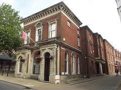
This street led to the Winchester Staple, established in 1326 as one of the ten sites in England where wool could be bought and sold for export. Merchants from Flanders, Bordeaux and Lombardy traded here. The Staple fell out of use when the rules regulating the wool industry were relaxed in the late 14th century, and the area was later used as the City rubbish dump.

Inscription drawn from imported open data, awaiting original TributeLegacy editorial.

Source: Open Plaques. Geographic data via OpenStreetMap.

Nearby locations in England

Browse all memorials in England

Data sources

Location records are drawn from open, licence-clean datasets, kept here with attribution and gratitude to the people who maintain them.

  • Open Plaques, dedicated to the public domain (CC0). See openplaques.org.
  • Wikidata, available under the CC0 1.0 Universal dedication.
  • © OpenStreetMap contributors, available under the Open Database Licence.
  • Historic England, National Heritage List for England, used under the Open Government Licence v3.0. War memorial records are drawn from open community datasets (OpenStreetMap, Wikidata, NHLE) — never from the Commonwealth War Graves Commission, which is excluded.

Editorial descriptions, photography and tribute links are original TributeLegacy work, layered on top of the open data.

Directions to here