 TributeLegacy
plaque · England
Walsall
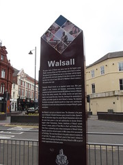
Walsall The place name of Walsall may derive from the Old English words 'Wealh', meaning a Briton and 'Halh' meaning a nook of land in a hollow. The medieval town of Walsall grew up in a cross shape, with the highest point, Church Hill, at its head, standing 511 feet above sea level. A church has been here since at least 1200 and St. Matthew's Church contains a 13th century inner crypt. Originally Walsall thrived as an important market town. With good supplies of coal, ironstone and limestone, metalworking industries prospered and light metalwork became the traditional industry of Walsall from the 16th century onwards. Bits, stirrups, buckles and spurs were made in and around the town. From this, developed the manufacture of saddlery and leather goods for which Walsall is famous. The Industrial Revolution encouraged industrial growth on a huge scale, exploiting the development of canal and railway networks to transport Walsall's goods everywhere. But Walsall is not just an industrial town. The Arboretum is the green heart of Walsall. A flooded limestone quarry formed its lakes. Opened in 1874. the Arboretum stages the annual Walsall Illuminations which over the years have grown in size and sophistication to become Britain's biggest inland illuminations. Famous inhabitants of Walsall include Jerome K. Jerome, author of 'Three Men in a Boat' and Dorothy Pattison, Sister Dora, a pioneering nurse whose development of Walsall Cottage Hospital, earned her national respect. In 1886 a statue of her was unveiled on The Bridge. This was Great Britain's first public statue of a woman not of royal birth. The people of Walsall, proud of their town's richness in culture, saw the opening of the New Art Gallery Walsall in 2000, as part of a major regeneration of the town centre.
Inscription drawn from imported open data, awaiting original TributeLegacy editorial.
Source: Open Plaques. Geographic data via OpenStreetMap.