 TributeLegacy
black plaque · England
The Trafalgar Way
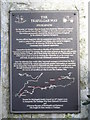
The Trafalgar Way Sticklepath On Monday 21st October 1805 the Royal Navy decisively defeated a combined French and Spanish fleet off Cape Trafalgar on the south west coast of Spain. This victory permanently removed the threat of invasion of England by the armies of Napoleon Bonaparte. The first official dispatches with the momentous news of the victory, and the death in action of Vice Admiral Lord Nelson, were carried to England on board H.M. Schooner Pickle by her captain, Lieutenant John Richards Lapenotiere. Lapenotiere landed at Falmouth on Monday 4th November 1805 and set out "express by post-chaise" for London. He took some 37 hours on the 271 mile journey, changing horses 21 times, one of these being very early on 5th at Okehampton. His orders were to lose no time in reaching the Admiralty so, as the horses were still fresh, he sped on through Sticklepath towards Crockernwell. Over the following four weeks other important messages arrived from the fleet with further details of the victory and anxiously awaited information on casualties. All the dispatches were landed at Falmouth and their couriers took the same route through Sticklepath where fresh horses and hospitality were available from the inns to all travellers on what is now The Trafalgar Way. Erected by Sticklepath Parish Council on 16th August 2005 to inaugurate The Trafalgar Way from Falmouth to London and to honour the men of Sticklepath and Dartmoor who fought for their country at Trafalgar.
Inscription drawn from imported open data, awaiting original TributeLegacy editorial.
Source: Open Plaques. Geographic data via OpenStreetMap.