blue plaque · England

The Murrill

Photograph at the The Murrill blue plaque

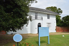
The Murrill. The house dates from the18th century. There had been a farm on this site for at least 500 years prior to the 1950s. Documents from the 16th century show it as the Manor of Morrels and part of the Southwick Priory Estate. Later it became known as Portchester Farm and was the home of the Curtis family from 1871 to 1951

Inscription drawn from imported open data, awaiting original TributeLegacy editorial.

Source: Open Plaques. Geographic data via OpenStreetMap.

Nearby locations in England

Browse all memorials in England

Data sources

Location records are drawn from open, licence-clean datasets, kept here with attribution and gratitude to the people who maintain them.

  • Open Plaques, dedicated to the public domain (CC0). See openplaques.org.
  • Wikidata, available under the CC0 1.0 Universal dedication.
  • © OpenStreetMap contributors, available under the Open Database Licence.
  • Historic England, National Heritage List for England, used under the Open Government Licence v3.0. War memorial records are drawn from open community datasets (OpenStreetMap, Wikidata, NHLE) — never from the Commonwealth War Graves Commission, which is excluded.

Editorial descriptions, photography and tribute links are original TributeLegacy work, layered on top of the open data.

Directions to here