 TributeLegacy
green plaque · England
Stock High Bridge
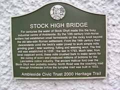
Stock High Bridge. For centuries the water of Stock Ghyll made this the busy industrial centre of Ambleside. By the 10th century Irish-Norse settlers had established small farmsteads on the rocky knoll beyond the old lake-side Roman settlement. From the 14th century their descendants used the beck's water power to work simple mills grinding grain; later washing, fulling and weaving wool. The first mill was established in 1335; the last in 1793. Much later, from local coppiced wood, these mills crushed bark to make tannin for the curing of skins and produced millions of bobbins for the Lancashire cotton industry. The ancient Hallicar ford over the Stock Ghyll was probably nearby. North Road was the coaching road through Ambleside before the turnpike road was built in 1833.
Inscription drawn from imported open data, awaiting original TributeLegacy editorial.
Source: Open Plaques. Geographic data via OpenStreetMap.