 TributeLegacy
plaque · England
Rosemary Alley
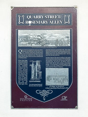
Quarry Street/Rosemary Alley Quarry Street was formerly the main road south to Horsham until Millbrook was built below it in 1961. Originally South Street, it became known as Quarry Street in Georgian times because it led to the great chalk pits just outside the town. The chalk was mainly used for lime, which was used as a fertiliser and in building mortar. Before Stuart times, most of the houses in Guildford were built of timber. The great oak woodlands which covered part of Surrey provided excellent building material and many late medieval and Tudor timber houses survive today. This house, 53 Quarry Street, dates from the early 17th century and has the characteristic 'jetty' - the upper floor projecting beyond the ground floor wall. The ceiling timbers inside still retain their original painted decoration. Opposite you can see two other timber-framed houses flanking what is now called Rosemary Alley - once an open drain that ran to the river. The timber-framed houses of Rosemary Alley lean together. St. Mary's Church is the oldest in Guildford. The central tower is late Saxon, dating from about 1050. Re-buildings and extensions over the next 200 years gave the church its present form. The east end - the chancel - used to extend further into the street, making a very narrow passage. It was shortened to its present length in 1825 to allow - it is said - George IV to travel in his coach more easily from Windsor to Brighton.
Inscription drawn from imported open data, awaiting original TributeLegacy editorial.
Source: Open Plaques. Geographic data via OpenStreetMap.