blue plaque · England

Lime Kiln Lane, Exmouth

Photograph at the Lime Kiln Lane, Exmouth blue plaque

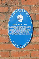
Lime Kiln Lane. The ancient lane, also known as Watery Lane, is so named from the route to the 18th century lime kiln situated on the present Maer. The lane was also used by smugglers to take contraband from Orcombe to Mutter's cider shop formerly located on the Salterton Road. Mutter was a local smuggler after whom Mutter's Moor was named which was the location of one of his look-out points near Sidmouth.

Inscription drawn from imported open data, awaiting original TributeLegacy editorial.

Source: Open Plaques. Geographic data via OpenStreetMap.

Nearby locations in England

Browse all memorials in England

Data sources

Location records are drawn from open, licence-clean datasets, kept here with attribution and gratitude to the people who maintain them.

  • Open Plaques, dedicated to the public domain (CC0). See openplaques.org.
  • Wikidata, available under the CC0 1.0 Universal dedication.
  • © OpenStreetMap contributors, available under the Open Database Licence.
  • Historic England, National Heritage List for England, used under the Open Government Licence v3.0. War memorial records are drawn from open community datasets (OpenStreetMap, Wikidata, NHLE) — never from the Commonwealth War Graves Commission, which is excluded.

Editorial descriptions, photography and tribute links are original TributeLegacy work, layered on top of the open data.

Directions to here