 TributeLegacy
plaque · England
King Henry III of England
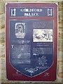
Guildford Palace The ruins you can see nearby are the remains of what was once one of the most luxurious royal residences in England. Guildford Castle was probably founded by William the Conqueror soon after 1066, with its prominent "motte" or mound with "bailey" to one side, enclosed by a ditch and a wall. The original bailey ditch seems to have run near the spot where you are now standing, until it was filled in when the bailey was extended to Quarry Street in about 1200. Here in the bailey there would originally have been timber buildings to house the garrison. These would have been replaced with stone during the 12th century and subsequently Henry III lavished a great deal of money on buildings and decorations here. The ruin to your right may well have been the King's Great Chamber, his private quarters when staying at Guildford. We know from Exchequer records that the chamber was panelled with wood, there was glass in the windows and the ceiling was decorated with moons and stars. The king had his own chapel nearby, as did the queen. Henry's wife, Eleanor of Provence, was a highly cultured woman who introduced colonnaded gardens and tiled pavements at Guildford. The life of the castle revolved around the Great Hall, which probably lay where the Victorian brick houses now stand. Nearby buildings would have accommodated the royal children, the officials, courtiers and servants who attended the royal family. After Henry III's death in 1272 the palace buildings were used less frequently and eventually allowed to fall into decay.
Inscription drawn from imported open data, awaiting original TributeLegacy editorial.
Source: Open Plaques. Geographic data via OpenStreetMap.