 TributeLegacy
green plaque · England
King Charles I of England
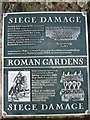
Siege Damage Looking ahead, you can see repairs to the stonework of the medieval City Wall. The unweathered masonry marks the site of a breach, battered through the wall by Parliamentary cannon, when Chester was besieged during the Civil War. By September 1645 Chester's loyal stand for King Charles I was nearing an end. The suburbs had been taken. The Royalist garrison and all the citizens took refuge inside the City Walls. Parliamentary troops mounted cannon at St John's Church, just east of here and bombared these south eastern defences. On Monday 22nd September the Walls here were attacked from 12 noon until 4pm. Thirty-two shots were fired, making a breach wide enough for "ten men abreast to enter". Two Royalist soliders were killed trying to fill the hole with beds and woolpacks. Roman Gardens That night, the Parliamentarians attemped to storm the breach, but were beaten back after fierce fighting. Hearing of the city's plight King Charles I arrived in Chester with a force of cavalry on 23rd September. The next day, his army was decisively defeated at the battle of Rowton Moor, one of the turning points of the Civil War. The Siege of Chester continued. Although the Walls were breached in other places, the Parliamentarians failed to enter the city until Chester surrendered in February 1646. Siege Damage
Inscription drawn from imported open data, awaiting original TributeLegacy editorial.
Source: Open Plaques. Geographic data via OpenStreetMap.