black plaque · England

Hugh de Gobion

Photograph at the Hugh de Gobion black plaque

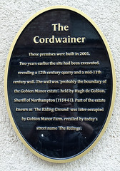
The Cordwainer These premises were built in 2001. Two years earlier the site had been excavated, revealing a 12th century quarry and a mid-13th century wall. The wall was 'probably the boundary of the Gobion Manor estate', held by Hugh de Gobion, Sheriff of Northampton (1154-61). Part of the estate known as 'The Riding Ground' was later occupied by Gobion Manor Farm, recalled by today's street name 'The Ridings'.

Inscription drawn from imported open data, awaiting original TributeLegacy editorial.

Source: Open Plaques. Geographic data via OpenStreetMap.

Nearby locations in England

Browse all memorials in England

Data sources

Location records are drawn from open, licence-clean datasets, kept here with attribution and gratitude to the people who maintain them.

  • Open Plaques, dedicated to the public domain (CC0). See openplaques.org.
  • Wikidata, available under the CC0 1.0 Universal dedication.
  • © OpenStreetMap contributors, available under the Open Database Licence.
  • Historic England, National Heritage List for England, used under the Open Government Licence v3.0. War memorial records are drawn from open community datasets (OpenStreetMap, Wikidata, NHLE) — never from the Commonwealth War Graves Commission, which is excluded.

Editorial descriptions, photography and tribute links are original TributeLegacy work, layered on top of the open data.

Directions to here