 TributeLegacy
bronze plaque · England
Guildhall, Walsall
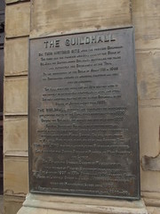
The Guildhall On this historic site were two previous Guildhalls. The first was the timbered medieval hall of the Guild of St. John the Baptist, whose Guildsmen controlled the trade and ultimately the Government of the Town. On the suppression of the Guild by Henry VIII in 1546 the Corporation assumed it's municipal functions and took over it's buildings. The hall survived until the mid 18th century when it was rebuilt or extensively remodelled in brick and stone. The only surviving feature of the second Guildhall is the Statue of Justice, dating from 1823. The Guildhall protected and symbolised the independence and borough status of the Town, first incorporated in c.1235. Outside the Guildhall the market has been here since 1220. The High Street was Walsall's only through route, all traffic having to surmount the steep slope of this thoroughfare up to the steps of the Parish Church. The hill is the origin of Walsall. Here we are at the heart of the Ancient Town. The Architect was George Benjamin Nichols of West Bromwich and London. The builder was Charles Burkitt of Wolverhampton. It was the seat of Walsall Government from it's opening on the 1st January 1867 to 27th September 1905, when the Council House in Lichfield Street was built. It continued however to house the Magistrates' Court until 1976. It's major restoration and conversion took place 1985-86.
Inscription drawn from imported open data, awaiting original TributeLegacy editorial.
Source: Open Plaques. Geographic data via OpenStreetMap.