black plaque · England

Dursley

Photograph at the Dursley black plaque

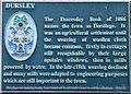
Dursley. The Domesday Book of 1086 names the town of Dersilege It was an agricultural settlement until the weaving of woollen cloth became common, firstly in cottages still recognisable by their large upstairs windows, when in mills powered by water. In the late c18th weaving declined and many mills were adapted to engineering purposes which are still important to the town. This place was funded by Dursley Town Council and Stroud District Council to make the millennium 2000AD.

Inscription drawn from imported open data, awaiting original TributeLegacy editorial.

Source: Open Plaques. Geographic data via OpenStreetMap.

Nearby locations in England

Browse all memorials in England

Data sources

Location records are drawn from open, licence-clean datasets, kept here with attribution and gratitude to the people who maintain them.

  • Open Plaques, dedicated to the public domain (CC0). See openplaques.org.
  • Wikidata, available under the CC0 1.0 Universal dedication.
  • © OpenStreetMap contributors, available under the Open Database Licence.
  • Historic England, National Heritage List for England, used under the Open Government Licence v3.0. War memorial records are drawn from open community datasets (OpenStreetMap, Wikidata, NHLE) — never from the Commonwealth War Graves Commission, which is excluded.

Editorial descriptions, photography and tribute links are original TributeLegacy work, layered on top of the open data.

Directions to here