black plaque · England

Crown Court, Godalming

Photograph at the Crown Court, Godalming black plaque

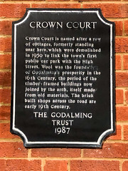
Crown Court is named after a row of cottages, formerly standing near here, which were demolished in 1950 to link the town's first public car park with the High Street. Wool was the foundation of Godalming's propserity in the 16th Century, the period of the timber-framed buildings now joined by the arch, itself made from old materials. The brick built shops across the road are early 19th Century.

Inscription drawn from imported open data, awaiting original TributeLegacy editorial.

Source: Open Plaques. Geographic data via OpenStreetMap.

Nearby locations in England

Browse all memorials in England

Data sources

Location records are drawn from open, licence-clean datasets, kept here with attribution and gratitude to the people who maintain them.

  • Open Plaques, dedicated to the public domain (CC0). See openplaques.org.
  • Wikidata, available under the CC0 1.0 Universal dedication.
  • © OpenStreetMap contributors, available under the Open Database Licence.
  • Historic England, National Heritage List for England, used under the Open Government Licence v3.0. War memorial records are drawn from open community datasets (OpenStreetMap, Wikidata, NHLE) — never from the Commonwealth War Graves Commission, which is excluded.

Editorial descriptions, photography and tribute links are original TributeLegacy work, layered on top of the open data.

Directions to here