black plaque · England

Black plaque № 42697

Photograph at the Black plaque № 42697 black plaque

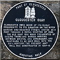
Gloucester Quay Gloucester owes much of its early prosperity to its location on the River Severn and received formal status as a port through a Royal Charter of 1580. The old quay was much frequented by sailing trows and barges working between Bristol and Shrewsbury, and continued to be used well into the 20th century. The present quay wall was constructed in 1887-8.

Inscription drawn from imported open data, awaiting original TributeLegacy editorial.

Source: Open Plaques. Geographic data via OpenStreetMap.

Nearby locations in England

Browse all memorials in England

Data sources

Location records are drawn from open, licence-clean datasets, kept here with attribution and gratitude to the people who maintain them.

  • Open Plaques, dedicated to the public domain (CC0). See openplaques.org.
  • Wikidata, available under the CC0 1.0 Universal dedication.
  • © OpenStreetMap contributors, available under the Open Database Licence.
  • Historic England, National Heritage List for England, used under the Open Government Licence v3.0. War memorial records are drawn from open community datasets (OpenStreetMap, Wikidata, NHLE) — never from the Commonwealth War Graves Commission, which is excluded.

Editorial descriptions, photography and tribute links are original TributeLegacy work, layered on top of the open data.

Directions to here