blue plaque · England

Alma Bridge

Photograph at the Alma Bridge blue plaque

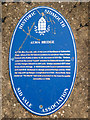
Alma Bridge In 1855, Mrs. Cornish, wife of the Lord of the Manor of Salcombe Regis, allowed the Sid Vale Association to construct Alma Bridge (named after Battle of Alma 1854), at a cost of £26.10s. Timbers came from the vessel "Laurel" wrecked on Sidmouth beach; steps cut into Hanger linked it to cliff path. Bridge repaired 1877 after heavy storm damage. In 1900 Sidmouth Council commissioned architect R.W.Sampson to design present bridge and by 1902 zig-zag path up Hanger completed for £150. Ham Field, then known as "The Marsh" had been presented to the town for public recreation in 1896.

Inscription drawn from imported open data, awaiting original TributeLegacy editorial.

Source: Open Plaques. Geographic data via OpenStreetMap.

Nearby locations in England

Browse all memorials in England

Data sources

Location records are drawn from open, licence-clean datasets, kept here with attribution and gratitude to the people who maintain them.

  • Open Plaques, dedicated to the public domain (CC0). See openplaques.org.
  • Wikidata, available under the CC0 1.0 Universal dedication.
  • © OpenStreetMap contributors, available under the Open Database Licence.
  • Historic England, National Heritage List for England, used under the Open Government Licence v3.0. War memorial records are drawn from open community datasets (OpenStreetMap, Wikidata, NHLE) — never from the Commonwealth War Graves Commission, which is excluded.

Editorial descriptions, photography and tribute links are original TributeLegacy work, layered on top of the open data.

Directions to here